Senseki Line
Introducing
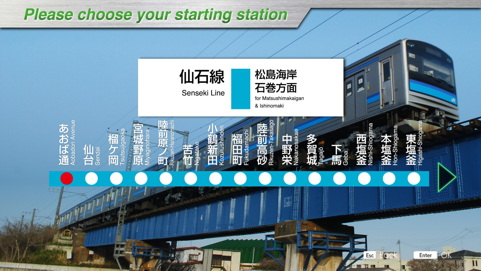
The Senseki Line is a 49.0 km long line connecting Sendai City in the central part of Miyagi Prefecture and Ishinomaki City in the northeast, and is the only DC electrified line in the Tohoku region. Like the Saikyo Line, ATACS is used in some sections (Aobadori Station to Higashi-Shiogama Station). In the Great East Japan Earthquake of March 11, 2011, the Senseki Line, which runs along the coast, was severely damaged by the earthquake and tsunami, and the entire line was shut down.
The line between Rikuzen-Otsuka and Rikuzen-Ono stations, located in low-lying areas and particularly heavily damaged, was relocated to higher ground inland, and resumed full service on May 30, 2015, four years after the line was closed.
In conjunction with the restoration of all lines, a connecting line was established between Matsushimakaigan Station and Takagimachi Station to connect from the Tohoku Main Line, and the "Senseki Tohoku Line" began direct service.
The Senseki Tohoku Line operates between Takagimachi Station and Ishinomaki Station, and HB-E210 series diesel trains also operate on the line.
The first half of the line (from Aobadori Station to Hon-Shiogama Station) runs through a bedroom town of Sendai, the middle part (from Hon-Shiogama Station to Tona Station) runs along Matsushima Bay with Matsushima, one of the three most scenic spots in Japan, at its side, and the latter half (from Tona to Ishinomaki Station) runs through a rural landscape.
Key data
- Line length: 49.0 km
- Number of stations: 32
- Safety system: ATACS / ATS-Ps
- Train model: 205-3100 series
- Max speed:
- Aobatori Av. ~ Higashi-Shiogama: 95km/h (ATACS)
- Higashi-Shiogama ~ Ishimaki: 95km/h (ATS-Ps)
- Max speed after signals:
- Reduced speed (green/yellow): 65 km/h
- Caution (yellow): 45 km/h
- Speed restriction (yellow/yellow): 25 km/h
- Routes:
- Aobatori Av. ~ Ishinomaki (1221S): "Local" - 4 cars - 32 stations - 49 km
- Aobatori Av. ~ Tagajo (763S): "Local" - 4 cars - 11 stations - 12.6 km
- Aobatori Av. ~ Matsushima-Kaigan (781S): "Local" - 4 cars - 17 stations - 23.2 km
The safety system is ATACS up to Higashi-Shiogama station. After that, it's ATS-Ps.
For the ATACS section, the Max Speed and Next Limit indicators are empty, and the light signals should be ignored.
As schedules are not available, it is advisable to use the timetables or display the STA indicator.
Console detail

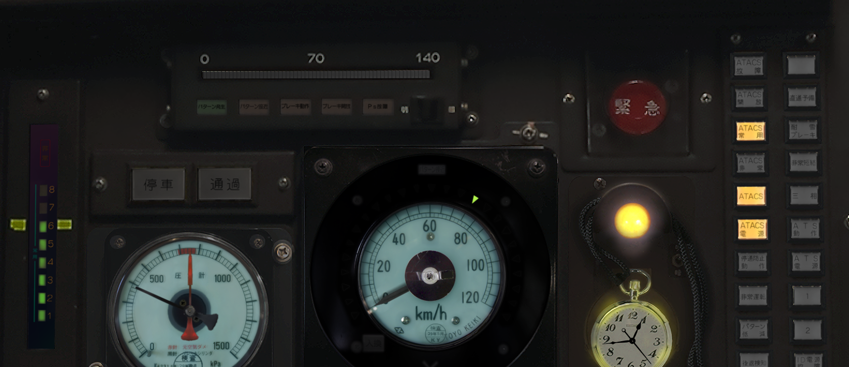
On the far left, we have the brake levels, with a yellow line on level 6 to indicate the level to apply when stopping and indicator for emergency brake in red (非常).
Then, at the top, we have the ATS-Ps display, with the following indicators:
- Presence of a pattern (パターン発生)
- Pattern approach (パターン接近)
- Brake operation (ブレーキ動作)
- Brake release (ブレーキ開放)
- Ps failure (Ps故障)
Below, on the left, 2 lights (unused) to indicate whether the next station is a stop (on the left - 停車) or just a passage (on the right - 通過). Still below, we have the brake pressure level (black arrow) and the compressed air reservoir (red arrow). Then we have the speed dial with the green ATACS speed limit indicators (and the light above telling us to brake if the limit is dropping, if it's on).
Then comes the lock indicator and the pocket watch.
Finally, we have various indicators for ATACS and ATS:
|
|
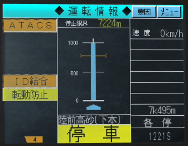
ATACS screen

The single screen contains some information about the line, when you're on the section using ATACS.
The left-hand column contains no relevant information.
The middle column contains several items of information:
- the distance to the next stop signal (not the distance to the next station stop)
- The next kilometer ahead. A white rectangle on the right means a station. An orange line means a level crossing.
- The name of the next station (here Rikuzen-Takasago/陸前高砂).
- The stop or passage indication for the next station.
Finally, the last column displays, from top to bottom, the current speed, distance travelled, type of journey and train number.
Movie
Useful links
Wikipedia: https://en.wikipedia.org/wiki/Senseki_Line
Driver's guide: https://docs.google.com/spreadsheets/d/1Hw8xuEEJTZLLzR22RwQkC6sJLlXACJDhcS-kG6KpiwM/edit#gid=1919488277
Timetables (in japanese):
- Aobatori Av. ~ Ishinomaki (1221S) : https://docs.google.com/spreadsheets/d/1Hw8xuEEJTZLLzR22RwQkC6sJLlXACJDhcS-kG6KpiwM/edit#gid=1185298684
- Aobatori Av. ~ Tagajo (763S) : https://docs.google.com/spreadsheets/d/1Hw8xuEEJTZLLzR22RwQkC6sJLlXACJDhcS-kG6KpiwM/edit#gid=1205254392
- Aobatori Av. ~ Matsushima-Kaigan (781S) : https://docs.google.com/spreadsheets/d/1Hw8xuEEJTZLLzR22RwQkC6sJLlXACJDhcS-kG6KpiwM/edit#gid=657354047

