The Lines
A description of each line in the simulator.
A map of the lines is available here : https://umap.openstreetmap.fr/fr/map/jr-east-train-simulator_1076114#7/38.324/140.120
- Lines map
- Keihin-Tohoku / Negishi Line
- Tokaido Line
- Chūō Line (Rapid Service)
- Oito Line
- Saikyo-Kawagoe Line
- Senseki Line
- Keiyo Line
- Yamanote Line
- Joban Line
- Shin-etsu Line
- Hachinohe Line
- Nambu Line
- Nambu Branch Line
- Tsurumi Line
- Sōbu Line (Rapid) - Narita Line
- Koumi Line
- Takasaki Line
- Rumoi Line (JR Hokkaido)
- Oga Line
- Narita Line
- Kashima Line
- Utsunomiya Line
- Yokosuka line
- Ōme Line
- Tōkaidō Freight Line
Lines map
Here is the map of all available lines. You can zoom in in order to see stations.
Keihin-Tohoku / Negishi Line

Introducing
The Keihin-Tōhoku line is a railway line in Japan's JR East network. It connects Ōmiya in Saitama Prefecture, Tokyo and Yokohama. The line, inaugurated in 1914, has been operating for over 100 years.
The line runs parallel to the JR Yamanote line between Shinagawa and Tabata stations. With a daily ridership of over 3 million, it is one of Japan's busiest commuter lines.
The Negishi Line is a railroad line in Japan's JR East network. It connects the stations of Yokohama and Ōfuna in Kanagawa Prefecture. There is no passenger service specific to the line: trains from the Keihin-Tōhoku line continue their service on the Negishi line.
This line is included in the basic set.
Key data
- Total length : 81.2 km
- Number of stations : 46
- Safety system : D-ATC
- Train model : E233-1000 series (10 cars)
- Max speed :
- Omiya ~ Sakuragicho : 90km/h
- Sakuragicho ~ Ofuna : 95km/h
- Routes :
- Omiya ~ Ofuna (1275A) : Rapid train - 40 stations - 81.2 km
- Omiya ~ Isogo (727B) : Local train - 41 stations - 68.6 km
- Omiya ~ Ofuna (1275A) : Rapid train - 40 stations - 81.2 km
- Automatic announcements: No
- Conductor announcements: Yes
- Driver announcement (pointing-and-calling): No
Features
Note that, because the safety system is the D-ATC, the warning lights must be ignored and the Max Speed / Next Limit indicators are empty.
Note also that, because the Akabane station has landing doors, the margin of error is +/- 35cm (as on the Yamanote), regardless of the difficulty setting, but TASC data is not available, so it can't be used in this case.
Stations list
| Station name |
Japanese name |
Distance from Ōmiya (km) |
Local |
Rapid |
JRETS connections |
|---|---|---|---|---|---|
| Ōmiya | 大宮 | 0 | ● | ● |
JU Takasaki JU Utsunomiya |
| Saitama-Shintoshin | さいたま新都心 | 1,6 | ● | ● |
JU Takasaki JU Utsunomiya |
| Yono | 与野 | 2,7 | ● | ● | |
| Kita-Urawa | 北浦和 | 4,3 | ● | ● | |
| Urawa | 浦和 | 6,1 | ● | ● |
JU Takasaki JU Utsunomiya |
| Minami-Urawa | 南浦和 | 7,8 | ● | ● | |
| Warabi | 蕨 | 10,6 | ● | ● | |
| Nishi-Kawaguchi | 西川口 | 12,5 | ● | ● | |
| Kawaguchi | 川口 | 14,5 | ● | ● | |
| Akabane | 赤羽 | 17,1 | ● | ● |
JU Takasaki JU Utsunomiya |
| Higashi-Jūjō | 東十条 | 18,9 | ● | ● | |
| Ōji | 王子 | 20,4 | ● | ● | |
| Kami-Nakazato | 上中里 | 21,5 | ● | ● | |
| Tabata | 田端 | 23,2 | ● | ● |
JY Yamanote |
| Nishi-Nippori | 西日暮里 | 24,0 | ● | | |
JY Yamanote |
| Nippori | 日暮里 | 24,5 | ● | | |
JY Yamanote JJ Jōban |
| Uguisudani | 鶯谷 | 25,6 | ● | | |
JY Yamanote |
| Ueno | 上野 | 26,7 | ● | ● |
JY Yamanote JJ Jōban JU Utsunomiya JU Takasaki |
| Okachimachi | 御徒町 | 27,3 | ● | | |
JY Yamanote |
| Akihabara | 秋葉原 | 28,3 | ● | ● |
JY Yamanote |
| Kanda | 神田 | 29,0 | ● | ● |
JY Yamanote JC Chūō (rapid) |
| Tokyo | 東京 | 30,3 | ● | ● |
JY Yamanote JC Chūō (rapid) (last stop) JT Tōkaidō JU Utsunomiya (last stop) JO Sōbu (Rapid) JE Keiyō (last stop) |
| Yūrakuchō | 有楽町 | 31,1 | ● | | |
JY Yamanote |
| Shimbashi | 新橋 | 32,2 | ● | | |
JY Yamanote JJ Jōban |
| Hamamatsuchō | 浜松町 | 33,4 | ● | ● |
JY Yamanote |
| Tamachi | 田町 | 34,9 | ● | ● |
JY Yamanote |
| Shinagawa | 品川 | 37,1 | ● | ● |
JY Yamanote JJ Jōban |
| Ōimachi | 大井町 | 39,5 | ● | ● | |
| Ōmori | 大森 | 41,7 | ● | ● | |
| Kamata | 蒲田 | 44,7 | ● | ● | |
| Kawasaki | 川崎 | 48,5 | ● | ● |
JT Tōkaidō JN Nambu |
| Tsurumi | 鶴見 | 52,0 | ● | ● |
JI Tsurumi |
| Shin-Koyasu | 新子安 | 55,1 | ● | ● | |
| Higashi-Kanagawa | 東神奈川 | 57,3 | ● | ● | |
| Yokohama | 横浜 | 59,1 | ● | ● | JT Tōkaidō JO Yokosuka |
| Sakuragichō | 桜木町 | 61,1 | ● | ● | |
| Kannai | 関内 | 62,1 | ● | ● | |
| Ishikawachō | 石川町 | 62.9 | ● | ● | |
| Yamate | 山手 | 64.1 | ● | ● | |
| Negishi | 根岸 | 66.2 | ● | ● | |
| Isogo | 磯子 | 68.8 | ● | ● |
|
| Shin-Sugita | 新杉田 | 70.2 | ● |
||
| Yōkōdai | 洋光台 | 73.2 | ● | ||
| Kōnandai | 港南台 | 75.1 | ● |
||
| Hongōdai | 本郷台 | 77.6 | ● |
||
| Ōfuna | 大船 | 81.2 | ● | JT Tōkaidō JO Yokosuka |
Movie
Useful links
Wikipedia : https://en.wikipedia.org/wiki/Keihin–Tōhoku_Line - https://en.wikipedia.org/wiki/Negishi_Line
Driver's guide and timetables: https://docs.google.com/spreadsheets/d/1qFyJVimA8cCBda6Iq064m5uuelpWd28X0FDERZQJ1fQ/edit#gid=426048143
Tokaido Line
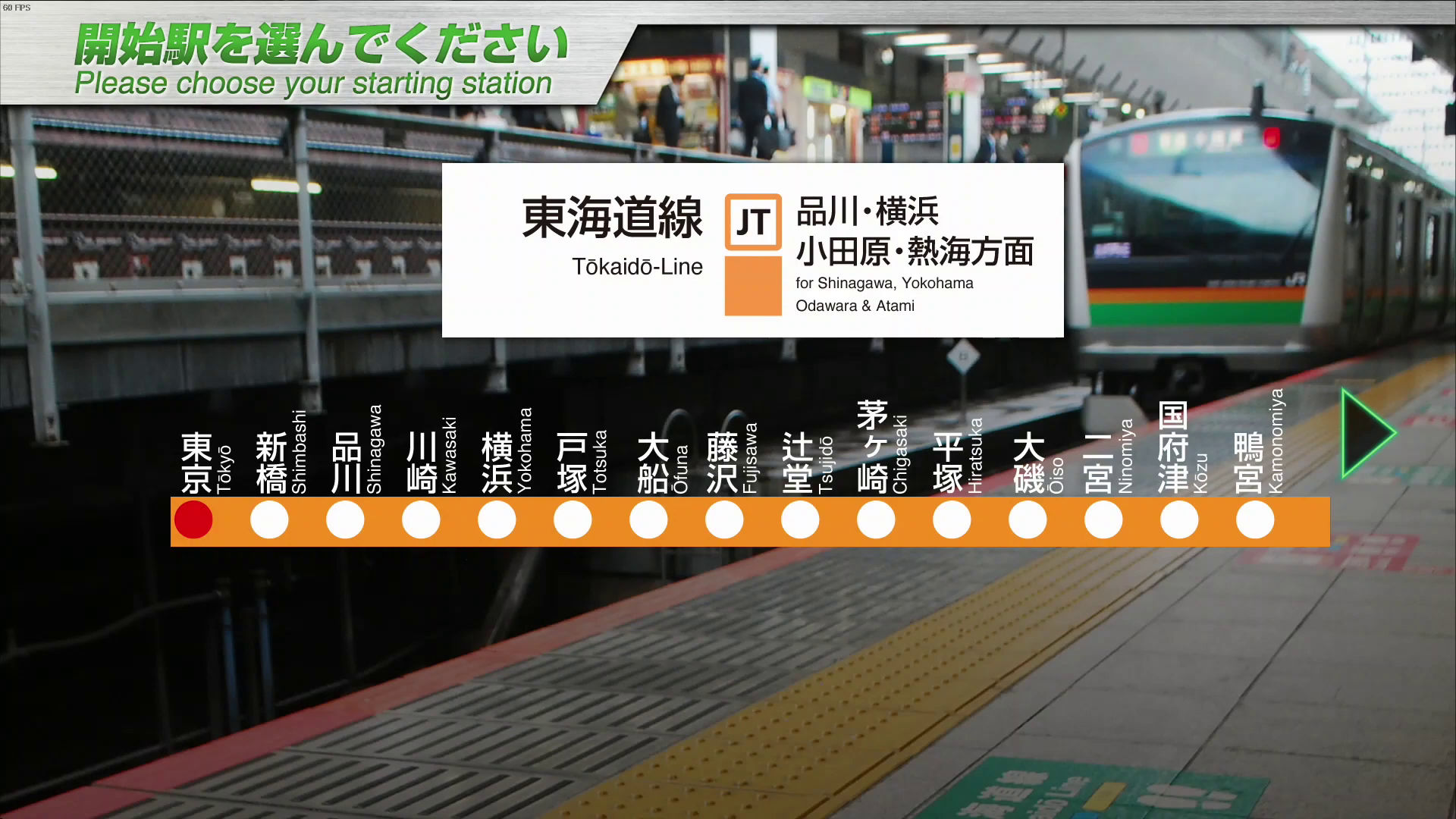
Introducing
The Tokaido Line was Japan's first railroad line, including the line between Shimbashi and Yokohama, which opened in 1872. It is known as one of Japan's most famous lines connecting Tokyo to Yokohama, Nagoya, Kyoto, and Osaka, and since the Tokaido Shinkansen began service in 1964, it has been used as a regional commuter line as well as a route connecting the long-known hot springs and tourist destinations of Atami, Hakone, and Izu. This time we can drive from Japan's capital, Tokyo, to the famous hot spring resort of Atami.
In the first half of the train, from the office district of Tokyo, the capital of Japan, and the Shinkansen and boarding scenery, you can see the blue sea of Sagami Bay on the left side of the train, Odawara Castle, one of the 100 most famous castles in Japan, on the right side of the train, Mt. Fuji, the highest mountain in Japan, passing by the Shinkansen while driving and enjoying scenic views while driving.
Key data
- Total length : 104.6 km
- Number of stations : 21
- Safety system : ATP-P
- Train model : E233-3000 series (10/15 cars)
- Max speed :
- Tokyo ~ Totsuka : 110km/h
- Totsuka ~ Odawara : 120km/h
- Odawara ~ Atami : 110km/h
- Tokyo ~ Totsuka : 110km/h
- Max speed after signals :
- Reduced speed (green/yellow) : 75 km/h
- Caution (yellow) : 55 km/h
- Speed restriction (yellow/yellow) : 25 km/h
- Routes :
- Tokyo ~ Atami (1865E) : Local train - 15 cars - 21 stations - 104.6 km
- Tokyo ~ Odawara (1525E) : Local train - 10 cars - 16 stations - 83.9 km
- Tokyo ~ Kōzu (1531E) : Local train - 15 cars - 14 stations - 77.7 km
- Tokyo ~ Hiratsuka (1567E) : Local train - 15 cars - 11 stations - 63.8 km
- Tokyo ~ Atami (3535E) : Rapid train "ACTY" - 15 cars - 17 stations - 104.6 km
- Automatic announcements: No
- Conductor announcements: Yes
- Driver announcement (pointing-and-calling): No
Features
The “Rapid ACTY” timetable was withdrawn on March 18, 2023 after 34 years of operation.
Train no. 1567E is also present on the Utsunomiya line, making it possible to link Utsunomiya ~ Tōkyō ~ Hiratsuka, a journey of over 170km.
Stations list
| Station name |
Japanese name |
Distance (km) | Rapid Acty |
Local | JRETS connections |
|---|---|---|---|---|---|
| Tokyo | 東京 | 0.0 | ● | ● |
JC Chūō (rapid) (last stop) JU Utsunomiya (last stop) JO Sōbu (Rapid) JJ Jōban JY Yamanote |
| Shimbashi | 新橋 | 1.9 | ● | ● | JY Yamanote JK Keihin–Tōhoku JO Yokosuka JJ Jōban |
| Shinagawa | 品川 | 6.8 | ● | ● | JY Yamanote JK Keihin–Tōhoku JO Yokosuka JJ Jōban |
| Kawasaki | 川崎 | 18.2 | ● | ● | JK Keihin–Tōhoku JN Nambu |
| Yokohama | 横浜 | 28.8 | ● | ● | |
| Totsuka | 戸塚 | 40.9 | ● | ● | JO Yokosuka |
| Ōfuna | 大船 | 46.5 | ● | ● | JK Negishi (last stop) JO Yokosuka |
| Fujisawa | 藤沢 | 51.1 | ● | ● | |
| Tsujidō | 辻堂 | 54.8 | | | ● | |
| Chigasaki | 茅ヶ崎 | 58.6 | ● | ● | |
| Hiratsuka | 平塚 | 63.8 | ● | ● | |
| Ōiso | 大磯 | 67.8 | | | ● | |
| Ninomiya | 二宮 | 73.1 | | | ● | |
| Kōzu | 国府津 | 77.7 | ● | ● | |
| Kamonomiya | 鴨宮 | 80.8 | | | ● | |
| Odawara | 小田原 | 83.9 | ● | ● | |
| Hayakawa | 早川 | 86.0 | ● | ● | |
| Nebukawa | 根府川 | 90.4 | ● | ● | |
| Manazuru | 真鶴 | 95.8 | ● | ● | |
| Yugawara | 湯河原 | 99.1 | ● | ● | |
| Atami | 熱海 | 104.6 | ● | ● |
Movie
Useful links
Wikipedia: https://en.wikipedia.org/wiki/T%C5%8Dkaid%C5%8D_Main_Line
Driver's guide and timetables: https://docs.google.com/spreadsheets/d/17Rczof1fTfbbFWPnqkOSgm8ijY-r-eJxqa5AHn71E70/edit#gid=371568555
Chūō Line (Rapid Service)
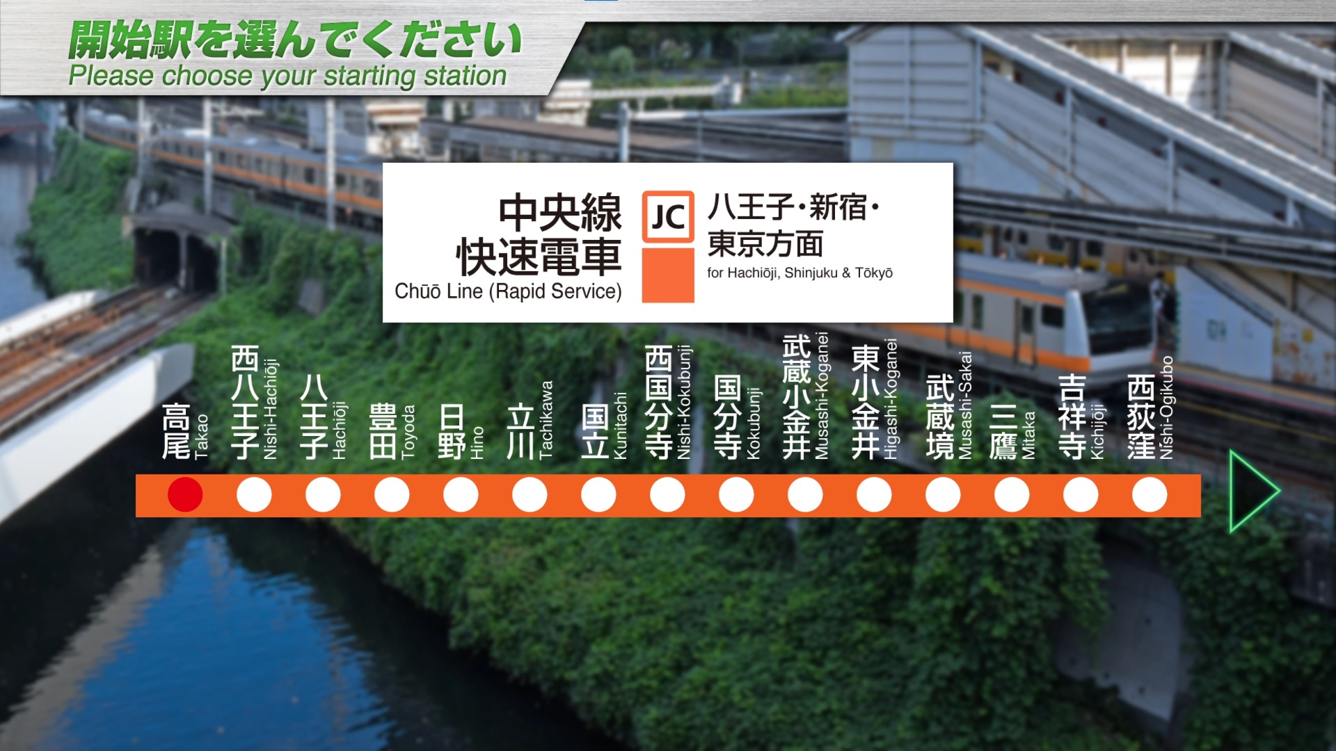
Introducing
The Chuo Line Rapid Service one of the major commuter lines in the Tokyo metropolitan area, connecting the Tama area, a bedroom community spreading in the western part of Tokyo, with Shinjuku, the world's largest terminal station, and the office areas of central Tokyo.
The line runs east to west in a straight line for more than 20 km through the center of Tokyo between Tachikawa Station and Nakano Station.
The line between Yotsuya and Ochanomizu Stations is characterized by the fact that the tracks are laid along the remains of the outer moat of Edo Castle, and passengers can enjoy the varied scenery of the outer moat of Edo Castle and the Kanda River.
The first half of the line is a commuter line running through a bedroom town, while the second half runs through the Akihabara Electric Town and the office district of central Tokyo.
Key data
- Line length : 53.1 km
- Number of stations : 24
- Safety system : ATS-P
- Train model : E233-0 series (10 cars)
- Max speed : 100 km/h
- Max speed after signals :
- Reduced speed (green/yellow) : 65 km/h
- Caution (yellow) : 45 km/h
- Speed restriction (yellow/yellow) : 25 km/h
- Routes :
- Tachikawa ~ Tokyo (602H) : "Commuter Special Rapid" - 7 stations - 37.5 km
- Takao ~ Tokyo (692T) : "Rapid" - 24 stations - 53.1 km
- Takao ~ Tokyo (916H) : "Chuo Special Rapid" - 14 stations - 53.1 km
- Tachikawa ~ Tokyo (1034T) : "Rapid" - 16 stations - 37.5 km
- Takao ~ Tokyo (1654T) : "Rapid" - 24 stations - 53.1 km
- Automatic announcements: No
- Conductor announcements: Yes
- Driver announcement (pointing-and-calling): No
Stations list
| Station name |
Japanese name |
Distance from Tokyo (km) |
Services | JRETS connections |
||
|---|---|---|---|---|---|---|
| Rapid | Rapid Spécial |
Commuter Rapid Special | ||||
| Takao | 高尾 | 53,1 | ● | ● | ||
| Nishi-Hachiōji | 西八王子 | 49,8 | ● | ● | ||
| Hachiōji | 八王子 | 47,4 | ● | ● | ||
| Toyoda | 豊田 | 43,1 | ● | ● | ||
| Hino | 日野 | 40,8 | ● | ● | ||
| Tachikawa | 立川 | 37,5 | ● | ● | ● |
JN Nambu (last stop) JC Ōme |
| Kunitachi | 国立 | 34,5 | ● | | | | | |
| Nishi-Kokubunji | 西国分寺 | 32,8 | ● | | | | | |
| Kokubunji | 国分寺 | 31,4 | ● | ● | ● | |
| Musashi-Koganei | 武蔵小金井 | 29,1 | ● | | | | | |
| Higashi-Koganei | 東小金井 | 27,4 | ● | | | | | |
| Musashi-Sakai | 武蔵境 | 25,7 | ● | | | | | |
| Mitaka | 三鷹 | 24,1 | ● | ● | | | |
| Kichijōji | 吉祥寺 | 22,5 | ● | | | | | |
| Nishi-Ogikubo | 西荻窪 | 20,6 | ● | | | | | |
| Ogikubo | 荻窪 | 18,7 | ● | | | | | |
| Asagaya | 阿佐ケ谷 | 17,3 | ● | | | | | |
| Kōenji | 高円寺 | 16,1 | ● | | | | | |
| Nakano | 中野 | 14,7 | ● | ● | | | |
| Shinjuku | 新宿 | 10,3 | ● | ● | ● |
JY Yamanote JA Saikyō |
| Yotsuya | 四ツ谷 | 6,6 | ● | ● | ● | |
| Ochanomizu | 御茶ノ水 | 2,6 | ● | ● | ● | |
| Kanda | 神田 | 1,3 | ● | ● | ● |
JY Yamanote |
| Tokyo | 東京 | 0 | ● | ● | ● |
JT Tōkaidō JU Utsunomiya (last stop) JO Sōbu (Rapid) JJ Jōban JY Yamanote |
Movie
Useful links
Wikipedia : https://en.wikipedia.org/wiki/Ch%C5%AB%C5%8D_Main_Line
Driver's guide and timetables: https://docs.google.com/spreadsheets/d/15ipf5Csaq6tgzw9Y2Atap77WVuTPDs74pZM4uwsJ3-U/edit#gid=1430578599
Oito Line

Introducing
The Oito Line is a 105.4 km long line connecting Matsumoto Station in Nagano Prefecture to Itoigawa Station in Niigata Prefecture. The 70.1 km route between Matsumoto Station and Minami-Kotani Station, which is under the jurisdiction of JR East, is well-known as a stop for customers visiting the mountain climbing and snow resort areas represented by Shinano-Omachi and Hakuba.
The "Super Azusa" limited express train runs directly from Shinjuku Station, and the line is also used as a commuter and school route in the Matsumoto area. From the driving scenery, you can experience the changing scenery of Shinshu from winter to spring with the magnificent snow-capped Northern Alps, cherry blossoms along the tracks, and rice paddies filled with water for the summer.
Key data
- Line length: 70.1 km
- Number of stations: 33
- Safety system: ATP-P / ATS-Ps
- Train model: 211 series (3 cars)
- Max speed:
- Matsumoto ~ Shinano Omachi : 95 km/h
- Shinano-Omachi ~ Minami-Otari : 85 km/h
- Max speed after signals:
- Reduced speed (green/yellow): 65 km/h
- Caution (yellow): 45 km/h
- Speed restriction (yellow/yellow): 25 km/h
- Routes:
- Matsumoto ~ Minami-Otari (5329M): Local train - 33 stations - 70.1 km
- Matsumoto ~ Hotaka (3113M): Local train - 11 stations - 16.2 km
- Matsumoto ~ Shinano-Omachi (3241M): Local train - 20 stations - 35.1 km
- Automatic announcements: No
- Conductor announcements: Yes
- Driver announcement (pointing-and-calling): Yes
Features
The ATS-P section only covers the link between the first 2 stations (Matsumoto - Kita-Matsumoto). The rest of the line is ATS-Ps.
This train uses 2 levers: a power lever and a brake lever. This allows the brakes to be released only when the engines are powered up (and avoids backing up slightly). However, apart from the keyboard, the mouse and joysticks manage them as if there were only one lever.
Stations list
| Station name |
Japanese name |
Distance (km) | JRETS connections |
|---|---|---|---|
| Matsumoto | 松本 | 0 | |
| Kita-Matsumoto | 北松本 | 0,7 | |
| Shimauchi | 島内 | 2,6 | |
| Shimatakamatsu | 島高松 | 3,8 | |
| Azusabashi | 梓橋 | 5,2 | |
| Hitoichiba | 一日市場 | 6,8 | |
| Nakagaya | 中萱 | 8,4 | |
| Minami-Toyoshina | 南豊科 | 10,4 | |
| Toyoshina | 豊科 | 11,4 | |
| Hakuyachō | 柏矢町 | 14,2 | |
| Hotaka | 穂高 | 16,2 | |
| Ariake | 有明 | 18,4 | |
| Azumi-Oiwake | 安曇追分 | 19,9 | |
| Hosono | 細野 | 22,8 | |
| Kita-Hosono | 北細野 | 23,8 | |
| Shinano-Matsukawa | 信濃松川 | 26,0 | |
| Azumi-Kutsukake | 安曇沓掛 | 28,6 | |
| Shinano-Tokiwa | 信濃常盤 | 30,9 | |
| Minami-Ōmachi | 南大町 | 34,0 | |
| Shinano-Ōmachi | 信濃大町 | 35,1 | |
| Kita-Ōmachi | 北大町 | 37,2 | |
| Shinano-Kizaki | 信濃木崎 | 39,4 | |
| Inao | 稲尾 | 41,6 | |
| Uminokuchi | 海ノ口 | 42,9 | |
| Yanaba | 簗場 | 46,3 | |
| Minami-Kamishiro | 南神城 | 52,8 | |
| Kamishiro | 神城 | 55,2 | |
| Iimori | 飯森 | 56,7 | |
| Hakuba | 白馬 | 59,7 | |
| Shinano-Moriue | 信濃森上 | 61,6 | |
| Hakubaōike | 白馬大池 | 65,4 | |
| Chikuni | 千国 | 68,7 | |
| Minami-Otari | 南小谷 | 70,1 |
Movie
Useful links
Wikipedia : https://en.wikipedia.org/wiki/%C5%8Cito_Line
Driver's guide and timetables: https://docs.google.com/spreadsheets/d/1HrP2b5rDiIn5zPMiYtB48x8VqJmd1hYuBGAQKlmt3Q4/edit#gid=1281070402
Saikyo-Kawagoe Line

Introducing
The Saikyo and Kawagoe Lines are one of the major commuter lines in the Tokyo metropolitan area, running from Osaki Station via Omiya Station to Kawagoe Station. From Osaki Station, the lines provide direct service to the Tokyo Waterfront Area Rapid Transit Rinkai Line in the direction of Shinkiba Station, and from Hazawa yokohama-kokudai Station to the Sotetsu Line in the direction of Ebina Station. This DLC includes only the Saikyo Line and Kawagoe Line between Osaki Station and Kawagoe Station.
The automatic train protection system switches twice on the way. (ATS-P between Osaki and Ikebukuro stations, ATACS between Ikebukuro and Omiya stations, and ATS-P between Omiya and Kawagoe stations)
The first half of the train runs through an office district in central Tokyo, the middle part through a bed town, and the latter half through a rural landscape with fields. Please enjoy the changing scenery along the line.
Key data
- Line length: 53 km
- Number of stations: 24
- Safety system: ATS-P / ATACS
- Train model: E233-7000 series (10 cars)
- Max speed :
- Osaki~Ikebukuro : 95km/h (ATS-P)
- Ikebukuro~Omiya : 100km/h (ATACS)
- Omiya~Kawagoe : 95km/h (ATS-P)
- Max speed after signals:
- Reduced speed (green/yellow): 75 km/h
- Caution (yellow): 55 km/h
- Speed restriction (yellow/yellow): 25 km/h
- Routes:
- Osaki ~ Kawagoe (1349F) : Rapid train - 20 stations - 53 km
- Osaki ~ Omiya (759K) : Local train - 19 stations - 36.1 km
- Automatic announcements: No
- Conductor announcements: Yes
- Driver announcement (pointing-and-calling): No
Liste des gares
| Station name |
Japanese name |
Distance from Ōsaki (km) | Local |
Rapid |
JRETS connections |
|---|---|---|---|---|---|
| Ōsaki | 大崎 | 0 | ● | ● | JY Yamanote |
| Ebisu | 恵比寿 | 3,6 | ● | ● | JY Yamanote |
| Shibuya | 渋谷 | 5,2 | ● | ● | JY Yamanote |
| Shinjuku | 新宿 | 8,6 | ● | ● |
JC Chūō (rapid) JY Yamanote |
| Ikebukuro | 池袋 | 13,4 | ● | ● | JY Yamanote |
| Itabashi | 板橋 | 15,2 | ● | ● | |
| Jūjō | 十条 | 16,9 | ● | ● | |
| Akabane | 赤羽 | 18,9 | ● | ● |
JU Takasaki JU Utsunomiya |
| Kita-Akabane | 北赤羽 | 20,4 | ● | | |
|
| Ukima-Funado | 浮間舟渡 | 22,0 | ● | | |
|
| Toda-Kōen | 戸田公園 | 24,4 | ● | ● | |
| Toda | 戸田 | 25,7 | ● | | |
|
| Kita-Toda | 北戸田 | 27,1 | ● | | |
|
| Musashi-Urawa | 武蔵浦和 | 29,5 | ● | ● | |
| Naka-Urawa | 中浦和 | 30,7 | ● | ● | |
| Minami-Yono | 南与野 | 32,4 | ● | ● | |
| Yonohommachi | 与野本町 | 34,0 | ● | ● | |
| Kita-Yono | 北与野 | 35,1 | ● | ● | |
| Ōmiya | 大宮 | 36,1 | ● | ● |
JU Takasaki JU Utsunomiya |
| Nisshin | 日進 | 3,7 | ● | ||
| Nishi-Ōmiya | 西大宮 | 6,3 | ● | ||
| Sashiōgi | 指扇 | 7,7 | ● | ||
| Minami-Furuya | 南古谷 | 12,4 | ● | ||
| Kawagoe | 川越 | 16,1 | ● |
Movie
Useful links
Wikipedia : https://en.wikipedia.org/wiki/Saiky%C5%8D_Line - https://en.wikipedia.org/wiki/Kawagoe_Line
Driver's guide and timetables: https://docs.google.com/spreadsheets/d/19VHpK5h7H3n8Hz5P7kCW_TY1h1sVssaQaJRo5FnO2Ww/edit#gid=382527808
Senseki Line

Introducing
The Senseki Line is a 49.0 km long line connecting Sendai City in the central part of Miyagi Prefecture and Ishinomaki City in the northeast, and is the only DC electrified line in the Tohoku region. Like the Saikyo Line, ATACS is used in some sections (Aobadori Station to Higashi-Shiogama Station). In the Great East Japan Earthquake of March 11, 2011, the Senseki Line, which runs along the coast, was severely damaged by the earthquake and tsunami, and the entire line was shut down.
The line between Rikuzen-Otsuka and Rikuzen-Ono stations, located in low-lying areas and particularly heavily damaged, was relocated to higher ground inland, and resumed full service on May 30, 2015, four years after the line was closed.
In conjunction with the restoration of all lines, a connecting line was established between Matsushimakaigan Station and Takagimachi Station to connect from the Tohoku Main Line, and the "Senseki Tohoku Line" began direct service.
The Senseki Tohoku Line operates between Takagimachi Station and Ishinomaki Station, and HB-E210 series diesel trains also operate on the line.
The first half of the line (from Aobadori Station to Hon-Shiogama Station) runs through a bedroom town of Sendai, the middle part (from Hon-Shiogama Station to Tona Station) runs along Matsushima Bay with Matsushima, one of the three most scenic spots in Japan, at its side, and the latter half (from Tona to Ishinomaki Station) runs through a rural landscape.
Key data
- Line length: 49.0 km
- Number of stations: 32
- Safety system: ATACS / ATS-Ps
- Train model: 205-3100 series (4 cars)
- Max speed: 95km/h
- Max speed after signals:
- Reduced speed (green/yellow): 65 km/h
- Caution (yellow): 45 km/h
- Speed restriction (yellow/yellow): 25 km/h
- Routes:
- Aobatori Av. ~ Ishinomaki (1221S): Local train - 32 stations - 49 km
- Aobatori Av. ~ Tagajo (763S): Local train - 11 stations - 12.6 km
- Aobatori Av. ~ Matsushima-Kaigan (781S): Local train - 17 stations - 23.2 km
- Automatic announcements: No
- Conductor announcements: Yes
- Driver announcement (pointing-and-calling): No (except for basic pack)
Features
The safety system is ATACS up to Higashi-Shiogama station. After that, it's ATS-Ps.
For the ATACS section, the Max Speed and Next Limit indicators are empty, and the light signals should be ignored.
As schedules are not available, it is advisable to use the timetables or display the STA indicator.
Stations list
| Station name |
Japanese name |
Distance from Aoba-dōri (km) | JRETS connections |
|---|---|---|---|
| Aoba-dōri | あおば通 | 0 | |
| Sendai | 仙台 | 0,5 | |
| Tsutsujigaoka | 榴ヶ岡 | 1,3 | |
| Miyaginohara | 宮城野原 | 2,4 | |
| Rikuzen-Haranomachi | 陸前原ノ町 | 3,2 | |
| Nigatake | 苦竹 | 4,0 | |
| Kozurushinden | 小鶴新田 | 5,6 | |
| Fukudamachi | 福田町 | 7,7 | |
| Rikuzen-Takasago | 陸前高砂 | 8,6 | |
| Nakanosakae | 中野栄 | 10,3 | |
| Tagajō | 多賀城 | 12,6 | |
| Geba | 下馬 | 14,4 | |
| Nishi-Shiogama | 西塩釜 | 15,2 | |
| Hon-Shiogama | 本塩釜 | 16,0 | |
| Higashi-Shiogama | 東塩釜 | 17,2 | |
| Rikuzen-Hamada | 陸前浜田 | 20,3 | |
| Matsushimakaigan | 松島海岸 | 23,2 | |
| Takagimachi | 高城町 | 25,5 | |
| Tetaru | 手樽 | 27,3 | |
| Rikuzen-Tomiyama | 陸前富山 | 28,6 | |
| Rikuzen-Ōtsuka | 陸前大塚 | 30,8 | |
| Tōna | 東名 | 32,2 | |
| Nobiru | 野蒜 | 33,4 | |
| Rikuzen-Ono | 陸前小野 | 36,0 | |
| Kazuma | 鹿妻 | 37,6 | |
| Yamoto | 矢本 | 40,2 | |
| Higashi-Yamoto | 東矢本 | 41,6 | |
| Rikuzen-Akai | 陸前赤井 | 43,1 | |
| Ishinomakiayumino | 石巻あゆみ野 | 45,2 | |
| Hebita | 蛇田 | 46,6 | |
| Rikuzen-Yamashita | 陸前山下 | 47,6 | |
| Ishinomaki | 石巻 | 49,0 |
Movie
Useful links
Wikipedia: https://en.wikipedia.org/wiki/Senseki_Line
Driver's guide and timetables: https://docs.google.com/spreadsheets/d/1Hw8xuEEJTZLLzR22RwQkC6sJLlXACJDhcS-kG6KpiwM/edit#gid=1919488277
Keiyo Line
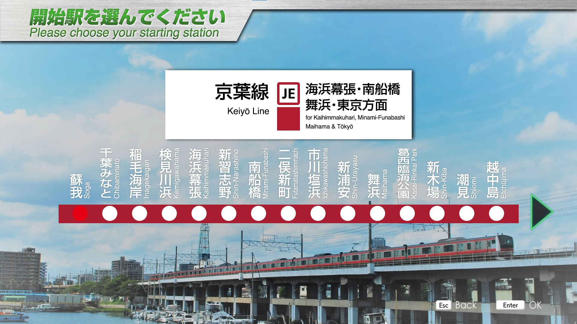
Introducing
The Keiyo Line, which opened in 1990, is a relatively young line within JR East, connecting Chiyoda-ku, Tokyo, with Chiba City, Chiba Prefecture.
Except for the underground section between Tokyo Station and Etchujima Station, the entire line is characterized by running on elevated tracks along Tokyo Bay. The area along the line is being redeveloped as reclaimed land on Tokyo Bay, and in addition to new towns, theme parks, large shopping malls, and offices are towering above the area.A delta line (connecting line) is provided from Nishi Funabashi Station on the Musashino Line to Ichikawa Shiohama Station and Minami Funabashi Station on the Keiyo Line, and Musashino Line trains operate directly to the Keiyo Line.
Key data
- Line length: 43 km
- Number of stations: 17
- Safety system: ATS-P
- Train model: E233-5000 series (10 cars)
- Max speed: 100 km/h
- Max speed after signals:
- Reduced speed (green/yellow): 75 km/h
- Caution (yellow): 55 km/h
- Speed restriction (yellow/yellow): 25 km/h
- Routes:
- Soga ~ Tokyo (1510Y): Local train - 17 stations - 43 km
- Soga ~ Tokyo (780Y): Local train - 17 stations - 43 km
- Automatic announcements: No
- Conductor announcements: Yes
- Driver announcement (pointing-and-calling): No
Stations list
| Station name |
Japanese name |
Distance from Tokyo (km) | JRETS connections |
|---|---|---|---|
| Soga | 蘇我 | 43,0 | |
| Chiba-Minato | 千葉みなと | 39,0 | |
| Inage-Kaigan | 稲毛海岸 | 35,3 | |
| Kemigawahama | 検見川浜 | 33,7 | |
| Kaihin-Makuhari | 海浜幕張 | 31,7 | |
| Makuharitoyosuna | 幕張豊砂 | 30,0 | |
| Shin-Narashino | 新習志野 | 28,3 | |
| Minami-Funabashi | 南船橋 | 26,0 | |
| Futamata-Shinmachi | 二俣新町 | 22,6 | |
| Ichikawa-Shiohama | 市川塩浜 | 18,2 | |
| Shin-Urayasu | 新浦安 | 16,1 | |
| Maihama | 舞浜 | 12,7 | |
| Kasairinkai-Kōen | 葛西臨海公園 | 10,6 | |
| Shin-Kiba | 新木場 | 7,4 | |
| Shiomi | 潮見 | 5,4 | |
| Etchūjima | 越中島 | 2,8 | |
| Hatchōbori | 八丁堀 | 1,2 | |
| Tokyo | 東京 | 0 |
JC Chūō (rapid) (last stop) JT Tōkaidō JU Utsunomiya (last stop) JO Sōbu (Rapid) JJ Jōban JY YamanoteJO Yokosuka (last stop) |
Movie
Useful links
Wikipedia: https://en.wikipedia.org/wiki/Keiy%C5%8D_Line
Driver's guide and timetables: https://docs.google.com/spreadsheets/d/1uvxb3tELhCmwDvdRfkYscjmj_4mbb01k4Q4aaB-6SaA/edit#gid=1823883666
Yamanote Line

Introducing
The Yamanote Line runs in a circle around the center of Tokyo for 34.5 km, taking 59 minutes, and is one of the major lines in the Tokyo metropolitan area, connecting huge terminal stations with world-class passengers. It runs parallel to the Keihin Tohoku Line between Shinagawa and Tabata stations, and the Saikyo Line and Shonan Shinjuku Line between Ikebukuro and Osaki stations.
Since most of the line runs parallel to other lines, many different types of rolling stock can be seen. The Yamanote Line has few level crossings, with only one crossing, the "Daini-Nakazato Level Crossing" between Tabata and Komagome Stations, the only crossing on the Yamanote Line.
The line is also characterized by its high frequency of service, with trains running every 3 to 4 minutes during the morning rush hour on weekdays, and every 5 minutes during the daytime on weekdays. Digital ATC is used as the security system.
Key data
- Line length: 34.5 km
- Number of stations: 29
- Safety system: D-ATC
- Train model: E235-0 series (11 cars)
- Max speed: 90 km/h
- Routes:
- Ōsaki~Ōsaki (1208G): Local train - 29 stations - 34.5 km
- Ōsaki~Ōsaki (876G): Local train - 29 stations - 34.5 km
- Automatic announcements: No
- Conductor announcements: Yes
- Driver announcement (pointing-and-calling): No
Features
The kanda station is the only one to have his station melody.
Since the safety system is the D-ATC, the warning lights must be ignored and the Max Speed / Next Limit indicators are empty.
TASC - Train Automatic Stopping Controller
As this line is equipped with landing doors, the margin of error for stopping is +/- 35cm, whatever the setting. However, as TASC data is available, it is possible to use TASC and the slow advance/inching function to make an automatic stop.
To do this, press "T" at the very beginning to activate TASC (deactivated by default). Then, when you arrive at the station, all you need to do is be at ~50km/h or less when you get within ~150m of the stop for TASC to activate and make the stop automatically.
If, for any reason, the train stops outside this limit, you can activate slow advance/inching using "I" key to advance/reverse at 2km/h max. to position yourself correctly. Once you're within the margin, TASC will take over to stop the train.
Stations list
| Station name |
Japanese name |
Distance | JRETS connections |
|---|---|---|---|
| Ōsaki | 大崎 | 0.0 |
JA Saikyō |
| Shinagawa | 品川 | 2.0 |
JT Tōkaidō |
| Tamachi | 田町 | 4.2 | |
| Hamamatsuchō | 浜松町 | 5.7 | |
| Shimbashi | 新橋 | 6.9 |
JT Tōkaidō |
| Yūrakuchō | 有楽町 | 8.0 | |
| Tokyo | 東京 | 8.8 |
JC Chūō (rapid) (last stop) JT Tōkaidō JU Utsunomiya (last stop) JO Sōbu (Rapid) JE Keiyō (last stop) |
| Kanda | 神田 | 10.1 |
JC Chūō (rapid) |
| Akihabara | 秋葉原 | 10.8 | |
| Okachimachi | 御徒町 | 11.8 | |
| Ueno | 上野 | 12.4 |
JJ Jōban JU Utsunomiya JU Takasaki |
| Uguisudani | 鶯谷 | 13.5 | |
| Nippori | 日暮里 | 14.6 |
JJ Jōban |
| Nishi-Nippori | 西日暮里 | 15.1 | |
| Tabata | 田端 | 15.9 | |
| Komagome | 駒込 | 17.5 | |
| Sugamo | 巣鴨 | 18.2 | |
| Ōtsuka | 大塚 | 19.3 | |
| Ikebukuro | 池袋 | 21.1 |
JA Saikyō |
| Mejiro | 目白 | 22.3 | |
| Takadanobaba | 高田馬場 | 23.2 | |
| Shin-Ōkubo | 新大久保 | 24.6 | |
| Shinjuku | 新宿 | 25.9 |
JC Chūō (rapid) JA Saikyō |
| Yoyogi | 代々木 | 26.6 | |
| Harajuku | 原宿 | 28.1 | |
| Shibuya | 渋谷 | 29.3 |
JA Saikyō |
| Ebisu | 恵比寿 | 30.9 |
JA Saikyō |
| Meguro | 目黒 | 32.4 | |
| Gotanda | 五反田 | 33.6 | |
| Ōsaki | 大崎 | 34.5 |
JA Saikyō |
Movie
Useful links
Wikipedia: https://en.wikipedia.org/wiki/Yamanote_Line
Driver's guide and timetables: https://docs.google.com/spreadsheets/d/11EzIt2dOjwZ_V4Ec4HMRwgWNXQFLfG9sTFj_pgl0Dko/edit#gid=119399473
Joban Line
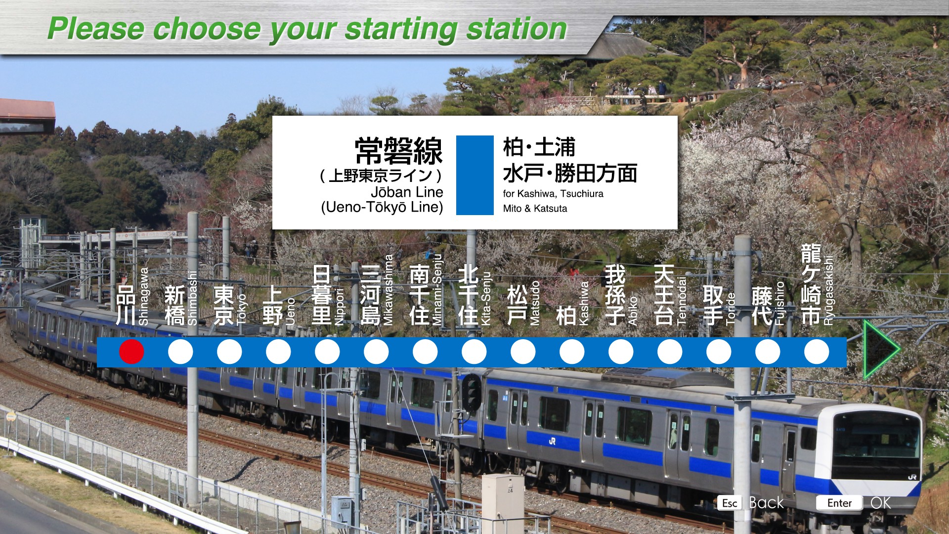
Introducing
The Joban Line runs from Ueno Station in Taito-ku, Tokyo, to Sendai Station in Sendai City, Miyagi Prefecture, via Chiba, Ibaraki, and Fukushima prefectures, and is the longest line among JR lines not named "Main Line. Until now, the Joban Line has operated to and from Ueno Station, but on March 14, 2015, the Ueno Tokyo Line began service, with some trains now running between Shinagawa and Ueno.
This DLC includes the Ueno Tokyo Line between Shinagawa Station and Ueno Station and the Joban Line between Ueno Station and Katsuta Station.
The line is characterized by the change of electrification system along the way, and there is a DC/AC switchover (dead section) between Toride and Fujishiro stations. (Shinagawa Station to Toride Station: 1500V DC, Fujishiro Station to Sendai Station: 20,000V AC)
Another major feature of this line is that it can operate at 130 km/h, the highest speed on a conventional JR line.
The first half of the line shows a significant change in scenery along the line from an office area in central Tokyo to a bed town. The second half of the line features the peaceful green landscape of Ibaraki Prefecture.
The long-distance route, which takes about two hours, allows passengers to enjoy driving while viewing the changing scenery along the route.
Key data
- Line Length: 133.7 km
- Number of stations: 29
- Safety system: ATS-P
- Train model: E531-0 series (10 cars)
- Max speed:
- Shinagawa ~ Nippori : 110 km/h
Nippori ~ Katsuta : 130 km/h (limite avec 🟩 : +10 km/h).
- Shinagawa ~ Nippori : 110 km/h
- Routes:
- Shinagawa ~ Katsuta (1177M) : Local train - 29 stations - 133.7 km
- Shinagawa ~ Tsuchiura (1157M) : Special Rapid train - 18 stations - 63.8 km
- Automatic announcements: No
- Conductor announcements: Yes
- Driver announcement (pointing-and-calling): No
Features
This line contains 6 dead sections, the first of which, between Toride and Fujishiro, involves a change of current (DC -> AC). Note that a voice warning is issued, as well as a flashing indicator at the top right of the right-hand screen, depending on the type of zone:
- DC -> AC changeover zone: "Mamonaku kōchoku section / 間もなく交直セクション" alert and "交直切換" indicator.
- Single neutral zone: "Mamonaku komogomo section / 間もなく交交セクション" alert and "交交" indicator.
Stations list
| Station name |
Japanese name |
Distance from Nippori (km) |
Local |
Special Rapid |
JRETS connections |
|---|---|---|---|---|---|
| Shinagawa |
品川 | 12,6 |
● | ● |
JY Yamanote |
| Shimbashi | 新橋 | 7,7 |
● | ● |
JY Yamanote |
| Tokyo |
東京 | 5,8 |
● | ● |
JY Yamanote JC Chūō (last stop) JO Sōbu (Rapid) JU Utsunomiya (last stop) JT Tokaido |
| Ueno |
上野 | 2,2 |
● | ● |
JY Yamanote JU Utsunomiya JU Takasaki |
| Nippori | 日暮里 | 0 | ● | ● |
JY Yamanote |
| Mikawashima | 三河島 | 1,2 | ● | | | |
| Minami-Senju | 南千住 | 3,4 | ● | | | |
| Kita-Senju | 北千住 | 5,2 | ● | ● | |
| Matsudo | 松戸 | 15,7 | ● | ● | |
| Kashiwa | 柏 | 26,9 | ● | ● | |
| Abiko | 我孫子 | 31,3 | ● | | | |
| Tennōdai | 天王台 | 34,0 | ● | | |
|
| Toride | 取手 | 37,4 | ● | ● | |
| Fujishiro | 藤代 | 43,4 | ● | ● | |
| Ryūgasakishi | 龍ケ崎市 | 45,5 | ● | ● | |
| Ushiku | 牛久 | 50,6 | ● | ● | |
| Hitachino-Ushiku | ひたち野うしく | 54,5 | ● | ● | |
| Arakawaoki | 荒川沖 | 57,2 | ● | ● | |
| Tsuchiura | 土浦 | 63,8 | ● | ● | |
| Kandatsu | 神立 | 69,9 | ● | ||
| Takahama | 高浜 | 76,4 | ● | ||
| Ishioka | 石岡 | 80,0 | ● | ||
| Hatori | 羽鳥 | 86,5 | ● | ||
| Iwama | 岩間 | 91,9 | ● | ||
| Tomobe | 友部 | 98,8 | ● | ||
| Uchihara | 内原 | 103,5 | ● | ||
| Akatsuka | 赤塚 | 109,3 | ● | ||
| Kairakuen | 偕楽園 | 113,4 | ● | ||
| Mito | 水戸 | 115,3 | ● | ||
| Katsuta | 勝田 | 121,1 | ● |
Movie
Useful links
Wikipedia : https://en.wikipedia.org/wiki/J%C5%8Dban_Line
Driver's guide and timetables: https://docs.google.com/spreadsheets/d/1bmmf3sH66l5TGKOQmtigAochaUtXWKdScnRs0oIa6y8/edit#gid=422915208
Shin-etsu Line
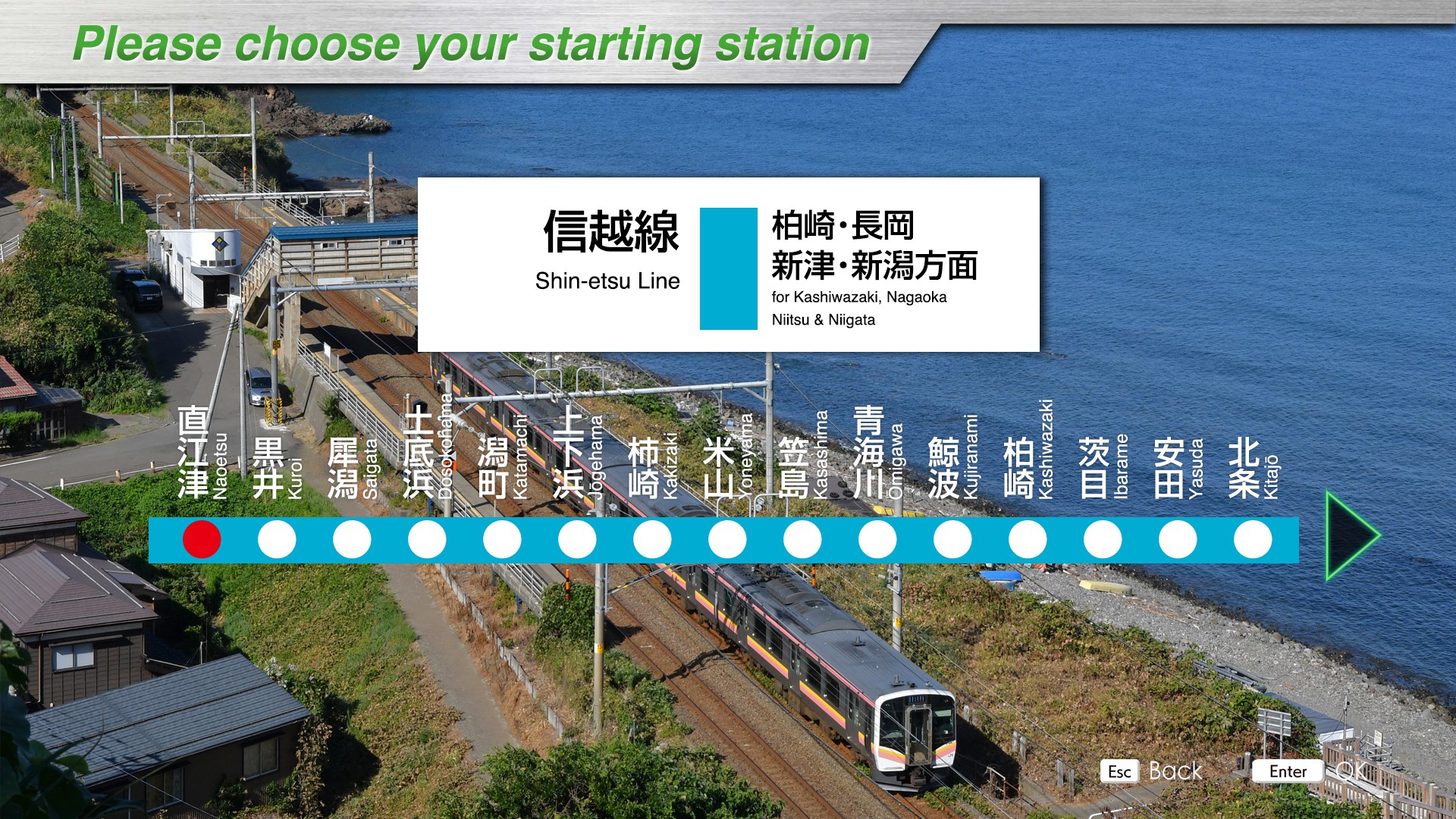
Introducing
The Shin-etsu Line connects Takasaki Station in Takasaki City, Gunma Prefecture with Niigata Station in Niigata City, Niigata Prefecture.
In the past, a single line connected Takasaki Station to Niigata Station, but with the opening of the Shinkansen line to Nagano (now Hokuriku Shinkansen) in October 1997, the line between Yokokawa Station and Karuizawa Station, which runs parallel to the Shinkansen line, was discontinued. At that time, the remaining line between Karuizawa Station and Shinonoi Station was also transferred to Shinano Railway. In March 2015, the Hokuriku Shinkansen line extension between Nagano and Kanazawa stations opened for service, and management of the line between Nagano and Naoetsu stations was also transferred to Shinano Railway and Echigo TOKImeki Railway.
Currently, the Shin-etsu Line operating as JR EAST has three sections: between Takasaki Station and Yokokawa Station, between Shinonoi Station and Nagano Station, and between Naoetsu Station and Niigata Station. This DLC includes the section between Naoetsu Station and Niigata Station.
Omigawa (青海川) Station, located on the way to the station, is known as a station adjacent to the sea, along with Umi-Shibaura Station on the Tsurumi Line and Rikuzen-Otsuka Station on the Senseki Line, where you can watch the sun set over the Sea of Japan from the platform.The train runs along the seaside section of the Sea of Japan between Naoetsu Station and Kashiwazaki Station, and between Kashiwazaki Station and Niigata Station, it runs through the rural landscape that symbolizes Niigata as a rice-producing region.
Key data
- Line length: 136.3 km
- Number of stations: 42
- Safety system: ATS-Ps/ATS-P
- Train model: E129 series (4 cars)
- Max speed: 100 km/h
- Routes:
- Naoetsu ~ Nagaoka (1327M): Local train -23 stations - 73 km
- Kashiwazaki ~ Niigata (1323M): Local train - 31 stations - 100 km
- Nagaoka ~ Niigata (431M): Local train - 20 stations - 63.3 km
- Nagaoka ~ Niigata (3481M): Rapid train - 9 stations - 63.3 km
- Niitsu ~ Niigata (2523M): Local train - 6 stations - 15.2 km
- Automatic announcements: No
- Conductor announcements: Yes
- Driver announcement (pointing-and-calling): No (except for basic pack)
Features
The ATS-P part only concerns the last 1200m before arriving at Niigata station.
A special feature of this DLC is that there is no line allowing you to do Naoetsu ~ Niigata in one go.
As schedules are not available on the TIMS screen, we recommend using the timetables or displaying the STA indicator.
Stations list
| Station name |
Japanese name |
Distance (km) | Local | Rapid |
JRETS connections |
|---|---|---|---|---|---|
| Naoetsu | 直江津 | 84.3 | ● | ||
| Kuroi | 黒井 | 87.0 | ● | ||
| Saigata | 犀潟 | 91.4 | ● | ||
| Dosokohama | 土底浜 | 93.7 | ● | ||
| Katamachi | 潟町 | 95.5 | ● | ||
| Jōgehama | 上下浜 | 98.3 | ● | ||
| Kakizaki | 柿崎 | 101.9 | ● | ||
| Yoneyama | 米山 | 107.8 | ● | ||
| Kasashima | 笠島 | 111.7 | ● | ||
| Ōmigawa | 青海川 | 113.9 | ● | ||
| Kujiranami | 鯨波 | 116.9 | ● | ||
| Kashiwazaki | 柏崎 | 120.6 | ● | ||
| Ibarame | 茨目 | 123.6 | ● | ||
| Yasuda | 安田 | 126.5 | ● | ||
| Kitajō | 北条 | 129.1 | ● | ||
| Echigo-Hirota | 越後広田 | 132.4 | ● | ||
| Nagatori | 長鳥 | 135.1 | ● | ||
| Tsukayama | 塚山 | 140.1 | ● | ||
| Echigo-Iwatsuka | 越後岩塚 | 144.8 | ● | ||
| Raikōji | 来迎寺 | 147.6 | ● | ||
| Maekawa | 前川 | 151.7 | ● | ||
| Miyauchi | 宮内 | 154.3 | ● | ||
| Nagaoka | 長岡 | 157.3 | ● | ● | |
| Kita-Nagaoka | 北長岡 | 159.8 | ● | | | |
| Oshikiri | 押切 | 164.2 | ● | | | |
| Mitsuke | 見附 | 168.7 | ● | ● | |
| Obiori | 帯織 | 172.8 | ● | | | |
| Tōkōji | 東光寺 | 175.4 | ● | | | |
| Sanjō | 三条 | 178.9 | ● | ● | |
| Higashi-Sanjō | 東三条 | 180.5 | ● | ● | |
| Honai | 保内 | 184.3 | ● | | | |
| Kamo | 加茂 | 188.1 | ● | ● | |
| Hanyūda | 羽生田 | 192.2 | ● | | | |
| Tagami | 田上 | 195.4 | ● | | | |
| Yashiroda | 矢代田 | 199.1 | ● | ● | |
| Furutsu | 古津 | 202.2 | ● | | | |
| Niitsu | 新津 | 205.4 | ● | ● | |
| Satsukino | さつき野 | 206.9 | ● | | | |
| Ogikawa | 荻川 | 209.2 | ● | | | |
| Kameda | 亀田 | 214.1 | ● | ● | |
| Echigo-Ishiyama | 越後石山 | 216.5 | ● | | | |
| Niigata | 新潟 | 220.6 | ● | ● |
Movies
Useful links
Wikipedia: https://en.wikipedia.org/wiki/Shin%27etsu_Main_Line
Driver's guide and timetables: https://docs.google.com/spreadsheets/d/13vyFcd7oDuORK3IjNlnSSNxdTPN-WXtBmYCRsaW8WR0/edit#gid=2085260494
Hachinohe Line

Introducing
The Hachinohe Line connects Hachinohe Station in Hachinohe City, Aomori Prefecture with Kuji Station in Kuji City, Iwate Prefecture.
The line was first opened in 1894 between Shiriuchi Station (now Hachinohe Station) and Hachinohe Station (now Hon'hachinohe Station), and was repeatedly extended and opened to service until 1930, when the line was extended to Kuji Station, bringing the Hachinohe Line into full service.
With the opening of the Tohoku Shinkansen bullet train line extension between Hachinohe and Shin-Aomori stations in December 2010, the line between Hachinohe and Aomori stations, which had previously been on the Tohoku Main Line, was transferred to Aomori Railway, and is now a line with no connections to other JR conventional lines.
In October 2013, "TOHOKU EMOTION," a sightseeing train with a restaurant space throughout the train, began operation between Hachinohe and Kuji Stations, mainly on Saturdays and holidays.
The train line is divided into two separate lines: one between Hachinohe Station and Same Station for urban transportation, and the other between Hachinohe and Kuji Station for interregional transportation.
The majority of the route runs along the coastline, including the Tanezaki Coast, a national scenic beauty spot and a breeding ground for petrels. From Hachinohe Station to Same Station, the line runs through factories and urban areas; from Same Station to Rikuchu-Nakano Station, it runs through rural areas and along the Pacific Ocean; and from Rikuchu-Nakano Station to Kuji Station, it runs through hilly areas. Some sections of the line offer views of the ocean, making it a popular route for passengers to see the ocean from the train windows.
Key data
- Line length: 64.9 km
- Number of stations: 24
- Safety system: ATS-Ps
- Train model: Kiha E130-500 (2 cars)
- Max speed: 85 km/h
- Max speed after signals:
- Reduced speed (green/yellow): 65 km/h
- Caution (yellow): 45 km/h
- Speed restriction (yellow/yellow): 25 km/h
- Routes:
- Hachinohe ~ Kuji (429D): "Local" - 24 stations - 64.9 km
- Hachinohe ~ Same (1431D): "Local" - 7 stations - 11.8 km
- Hachinohe ~ Kuji (441D): "Local" - 24 stations - 64.9 km
- Hachinohe ~ Same (1447D): "Local" - 7 stations - 11.8 km
- Automatic announcements: No
- Conductor announcements: Yes
- Driver announcement (pointing-and-calling): Yes
Features
As schedules are not available on the DICS screen, we recommend using the timetables or displaying the STA indicator.
On this line, train departure is only authorized when the buzzer sounds. The buzzer sounds when the conductor validates departure.
Stations list
| Station name |
Japanese name |
Distance (km) | JRETS connections |
|---|---|---|---|
| Hachinohe | 八戸 | 0 | |
| Naganawashiro | 長苗代 | 3,4 | |
| Hon-Hachinohe | 本八戸 | 5,5 | |
| Konakano | 小中野 | 7,3 | |
| Mutsu-Minato | 陸奥湊 | 9,0 | |
| Shirogane | 白銀 | 10,3 | |
| Same | 鮫 | 11,8 | |
| Mutsu-Shirahama | 陸奥白浜 | 17,5 | |
| Tanesashi-Kaigan | 種差海岸 | 19,6 | |
| Ōkuki | 大久喜 | 21,8 | |
| Kanehama | 金浜 | 24,8 | |
| Ōja | 大蛇 | 25,8 | |
| Hashikami | 階上 | 27,5 | |
| Kadonohama | 角の浜 | 29,5 | |
| Hiranai | 平内 | 32,1 | |
| Taneichi | 種市 | 34,1 | |
| Tamagawa | 玉川 | 38,1 | |
| Shukunohe | 宿戸 | 40,0 | |
| Rikuchū-Yagi | 陸中八木 | 43,1 | |
| Uge | 有家 | 45,8 | |
| Rikuchū-Nakano | 陸中中野 | 48,4 | |
| Samuraihama | 侍浜 | 54,4 | |
| Rikuchū-Natsui | 陸中夏井 | 61,7 | |
| Kuji | 久慈 | 64,9 |
Movie
Useful links
Wikipedia: https://en.wikipedia.org/wiki/Hachinohe_Line
Driver's Guide and timetables: https://docs.google.com/spreadsheets/d/1H7R4lfMNA8EnuSvzVVlOHqA-_LYPZ6TjGbp_C1YqVuQ/edit#gid=261872662
Nambu Line

Introducing
The Nambu Line is a 35.5 km long line connecting Kawasaki Station in Kawasaki City, Kanagawa Prefecture and Tachikawa Station in Tachikawa City, Tokyo.
The predecessor of the Nambu Line was a private railroad company, Nambu Railway, which opened between Kawasaki Station and Noborito Station in 1927 for the purpose of transporting gravel from the Tama River. Later, in 1929, the entire line between Kawasaki and Tachikawa Stations, in its present form, was opened.
It is a commuter and school route that intersects with the Chuo Line rapid service radiating from central Tokyo, private railway lines, Yokosuka Line, Tokaido Line, and many other lines, connecting them in a circle, and is used as an important means of access between central Tokyo and the Tama region in the southern northern part of Kanagawa Prefecture.
Many electronics manufacturers and IT-related companies are located along the line, and the Musashi-Kosugi Station area is lined with high-rise condominiums as well as natural scenery such as the Tama River. The area is also characterized by many boat and bicycle racetracks and horse racing tracks.
In 2011, rapid transit service was restored for the first time in 32 years, and currently the fastest connection from Kawasaki Station to Tachikawa Station is 43 minutes.
Key data
- Line Length: 35.5 km
- Number of stations: 26
- Safety system: ATS-P
- Train model: E233-8000 series (6 cars)
- Max speed: 95 km/h
- Max speed after signals:
- Reduced speed (green/yellow): 75 km/h
- Caution (yellow): 55 km/h
- Speed restriction (yellow/yellow): 25 km/h
- Routes:
- Kawasaki ~ Tachikawa (603F): "Local" - 26 stations - 35.5 km
- Kawasaki ~ Musashi-Nakahara (843F): "Local" - 8 stations - 9.2 km
- Kawasaki ~ Tachikawa (4027F): "Rapid" - 26 stations - 35.5 km
- Automatic announcements: No
- Conductor announcements: Yes
- Driver announcement (pointing-and-calling): No
Features
When you're on the rapid line, you have to notify the conductor, using the buzzer (B key) when the train passes through a station.
Stations list
| Station name |
Japanese name |
Distance (km) | JRETS connections |
|---|---|---|---|
| Kawasaki | 川崎 | 0 |
JT Tōkaidō |
| Shitte | 尻手 | 1,7 | JN Nambu branch |
| Yakō | 矢向 | 2,6 | |
| Kashimada | 鹿島田 | 4,1 | |
| Hirama | 平間 | 5,3 | |
| Mukaigawara | 向河原 | 6,6 | |
| Musashi-Kosugi | 武蔵小杉 | 7,5 | |
| Musashi-Nakahara | 武蔵中原 | 9,2 | |
| Musashi-Shinjō | 武蔵新城 | 10,5 | JO Yokosuka |
| Musashi-Mizonokuchi | 武蔵溝ノ口 | 12,7 | |
| Tsudayama | 津田山 | 13,9 | |
| Kuji | 久地 | 14,9 | |
| Shukugawara | 宿河原 | 16,2 | |
| Noborito | 登戸 | 17,3 | |
| Nakanoshima | 中野島 | 19,5 | |
| Inadazutsumi | 稲田堤 | 20,8 | |
| Yanokuchi | 矢野口 | 22,4 | |
| Inagi-Naganuma | 稲城長沼 | 24,1 | |
| Minami-Tama | 南多摩 | 25,5 | |
| Fuchū-Hommachi | 府中本町 | 27,9 | |
| Bubaigawara | 分倍河原 | 28,8 | |
| Nishifu | 西府 | 30,0 | |
| Yaho | 谷保 | 31,6 | |
| Yagawa | 矢川 | 33,0 | |
| Nishi-Kunitachi | 西国立 | 34,3 | |
| Tachikawa | 立川 | 35,5 |
JC Ōme |
Movie
Useful links
Wikipedia: https://en.wikipedia.org/wiki/Nambu_Line
Driver's guide and timetables: https://docs.google.com/spreadsheets/d/1Jzx47I9DaAdVm43REOtTeUY_cp4islfIgMYW6-8V3ew/edit#gid=820524735
Nambu Branch Line

Introducing
The Nambu Branch Line is a 4.1 km long line connecting Shitte Station in Kawasaki City, Kanagawa Prefecture and Hama-Kawasaki Station in Kawasaki City, Kanagawa Prefecture.
It does not operate directly with the Nambu Line, but operates a short distance to Hama-Kawasaki Station as a branch line that splits from the Nambu Line's Shitte Station. The opening of a new station, Odasakae Station, in March 2016 was also a major topic of conversation. The line runs between industrial areas and quiet residential areas.
Key data
- Line Length: 4.1 km
- Number of stations: 5
- Safety system: ATS-P
- Train model: 205-1000 series (2 cars)
- Max speed:
- Hama-Kawasaki~Kawasaki-Shinmachi: 95 km/h
- Kawasaki-Shinmachi~Shitte: 85 km/h
- Max speed after signals:
- Reduced speed (green/yellow): 65 km/h
- Caution (yellow): 45 km/h
- Speed restriction (yellow/yellow): 25 km/h
- Routes:
- Odasakae ~ Shitte (613H) : "Local" - 4 stations - 2.7 km
- Hama-Kawasaki ~ Shitte (721H) : "Local" - 5 stations - 4.1 km
- Hama-Kawasaki ~ Shitte (1401H) : "Local" - 5 stations - 4.1 km
- Automatic announcements: No
- Conductor announcements: Yes
- Driver announcement (pointing-and-calling): No
Features
Due to the small number of stations on this line, the TIMS screen will always display the complete line.
Stations list
| Station name |
Japanese name |
Distance (km) | JRETS connections |
|---|---|---|---|
| Shitte | 尻手 | 0 | JN Nambu |
| Hatchōnawate | 八丁畷 | 1,1 | |
| Kawasaki-Shinmachi | 川崎新町 | 2,0 | |
| Odasakae | 小田栄 | 2,7 | |
| Hama-Kawasaki | 浜川崎 | 4,1 | JI Tsurumi |
Movie
Useful links
Wikipedia: https://en.wikipedia.org/wiki/Nambu_Line#Nambu_Branch_Line
Driver's guide and timetables: https://docs.google.com/spreadsheets/d/1Jzx47I9DaAdVm43REOtTeUY_cp4islfIgMYW6-8V3ew/edit#gid=1507452507
Tsurumi Line

Introducing
The Tsurumi Line is a 9.7 km long line connecting Tsurumi Station in Yokohama City, Kanagawa Prefecture and Ogimachi Station in Kawasaki City, Kanagawa Prefecture.
In addition to the main line connecting Tsurumi Station and Ogimachi, the line has two branch lines: the Umi-Shibaura branch line, which branches off from Asano Station and connects to Umi-Shibaura Station, and the Okawa branch line, which branches off from Musashi-Shiraishi Station and connects to Okawa Station. Since the station is located in the Keihin Industrial Zone, it is used as a commuter stop by people commuting to factories along the line. Umi-Shibaura Station, along with Omigawa Station on the Shin-etsu Line and Rikuzen-Otsuka Station on the Senseki Line, is known as a station adjacent to the sea, and the Keihin Canal can be seen from the platform. Also, stray cats live in Ogimachi and Asano Stations and greet passengers as they please. Despite its proximity to the city, the line has a loose atmosphere.
Key data
- Line Length: 9.7 km
- Number of stations: 13
- Safety system: ATS-P
- Train model: 205-1100 series (3 cars)
- Max speed: 85 km/h
- Max speed after signals:
- Reduced speed (green/yellow): 65 km/h
- Caution (yellow): 45 km/h
- Speed restriction (yellow/yellow): 25 km/h
- Routes:
- Tsurumi ~ Ogimachi (701): "Local" - 10 stations - 7 km
- Tsurumi ~ Umi-Shibaura (705): "Local" - 7 stations - 4.7 km
- Tsurumi ~ Okawa (801): "Local" - 7 stations - 5.1 km
- Tsurumi ~ Hama-Kawasaki (1013): "Local" - 8 stations - 5.7 km
- Automatic announcements: No
- Conductor announcements: Yes
- Driver announcement (pointing-and-calling): No
Stations list
| Station name |
Japanese name |
Distance from Tsurumi (km) | JRETS connections |
|---|---|---|---|
| Main branch |
|||
| Tsurumi | 鶴見 | 0 | JK Keihin–Tōhoku |
| Kokudō | 国道 | 0,9 | |
| Tsurumi-Ono | 鶴見小野 | 1,5 | |
| Bentembashi | 弁天橋 | 2,4 | |
| Asano | 浅野 | 3,0 | JI Tsurimi (Umi-Shibaura branch) |
| Anzen | 安善 | 3,5 | JI Tsurimi (Ōkawa branch) |
| Musashi-Shiraishi | 武蔵白石 | 4,1 | |
| Hama-Kawasaki | 浜川崎 | 5,7 | JN Nambu |
| Shōwa | 昭和 | 6,4 | |
| Ōgimachi | 扇町 | 7,0 | |
| Umi-Shibaura branch |
|||
| Asano | 浅野 | 3,0 | JI Tsurimi (Main branch) |
| Shin-Shibaura | 新芝浦 | 3,9 | |
| Umi-Shibaura | 海芝浦 | 4,7 | |
| Ōkawa branch |
|||
| Anzen | 安善 | 3,5 | JI Tsurimi (Main branch) |
| Ōkawa | 大川 | 5,1 | |
Movies
Useful links
Wikipedia: https://en.wikipedia.org/wiki/Tsurumi_Line
Driver's guide:
- Tsurumi ~ Ogimachi: https://docs.google.com/spreadsheets/d/1vhGv2Bq_CUhS2W8Yl--mwYraEG7MXaqXCGoosgJIoqw/edit#gid=46757066
- Tsurumi ~ Umi-Shibaura: https://docs.google.com/spreadsheets/d/1vhGv2Bq_CUhS2W8Yl--mwYraEG7MXaqXCGoosgJIoqw/edit#gid=30084396
- Tsurumi ~ Okawa: https://docs.google.com/spreadsheets/d/1vhGv2Bq_CUhS2W8Yl--mwYraEG7MXaqXCGoosgJIoqw/edit#gid=1570595955
Timetables (in japanese):
- Tsurumi ~ Ogimachi (701): https://docs.google.com/spreadsheets/d/1vhGv2Bq_CUhS2W8Yl--mwYraEG7MXaqXCGoosgJIoqw/edit#gid=1243999982
- Tsurumi ~ Umi-Shibaura (705): https://docs.google.com/spreadsheets/d/1vhGv2Bq_CUhS2W8Yl--mwYraEG7MXaqXCGoosgJIoqw/edit#gid=139525495
- Tsurumi ~ Okawa (801): https://docs.google.com/spreadsheets/d/1vhGv2Bq_CUhS2W8Yl--mwYraEG7MXaqXCGoosgJIoqw/edit#gid=857680700
- Tsurumi ~ Hama-Kawasaki (1013): https://docs.google.com/spreadsheets/d/1vhGv2Bq_CUhS2W8Yl--mwYraEG7MXaqXCGoosgJIoqw/edit#gid=981607038
Sōbu Line (Rapid) - Narita Line
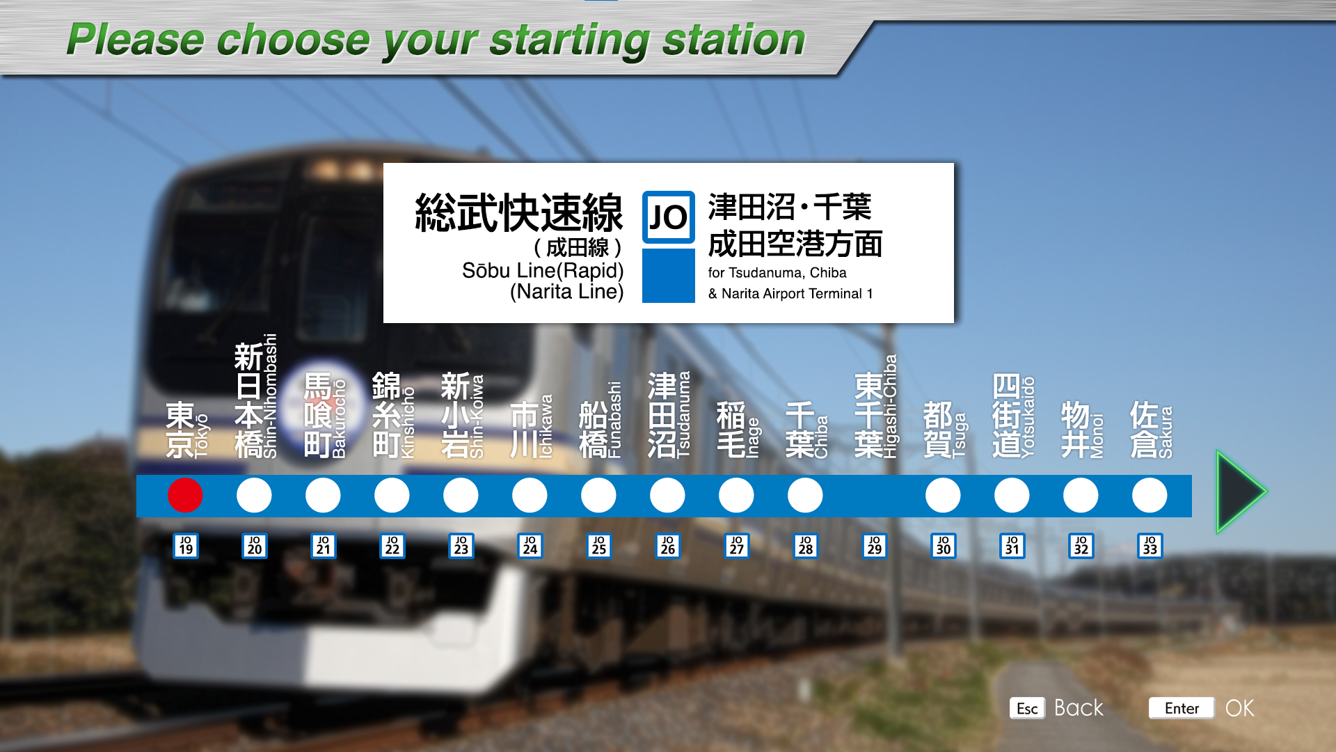
Introducing
The Sobu Rapid Line is a 79.2 km long line running east-west between Tokyo Station in Tokyo's Chiyoda Ward and Chiba Station in Chiba City, Chiba Prefecture.
The line also operates a direct connection with the Yokosuka Line between Tokyo Station and Kurihama Station in Yokosuka City, Kanagawa Prefecture, and Tokyo Station in Chiyoda Ward, Tokyo.
The Sobu Line (Rapid) operates at high speed, stopping only at a limited number of stations, because the Chuo・Sobu Line (Local) run side by side from Kinshicho Station to Chiba Station, which has a large number of stations.
The Sobu Line (Rapid) is also used as an access line between central Tokyo and Narita Airport, an international airport. The Narita Express, a limited express train bound for Narita Airport, runs on the Sobu Line (Rapid), and the Shiosai, a limited express train bound for Choshi, also runs on this line.
Trains bound for Narita Airport depart from Chiba Station via the Sobu Main Line and enter the Narita Line at Sakura Station. The Narita Line connects Sakura Station in Sakura City, Chiba Prefecture, and Matsugishi Station in Choshi City, Chiba Prefecture, via Narita Station. The Narita Line also has branch lines, one connecting Abiko Station in Abiko City, Chiba Prefecture, to Narita Station (commonly known as the Abiko Branch Line) and another connecting Narita Station to Narita Airport (commonly known as the Airport Branch Line).
The Sobu Line (Rapid) DLC can operate the section of the Narita Line from Sakura Station to Narita Airport Terminal 1 Station via Narita Station.
Starting underground in central Tokyo, the line runs at high speed through the suburbs of Tokyo and Chiba Prefecture, and beyond Chiba Station, the line runs through a landscape with a lot of greenery. We hope you will enjoy driving to Narita Airport while feeling the changes in the scenery.
Key data
- Line Length: 79.2km
- Number of stations: 19
- Safety system: ATS-P
- Train model: E217 series (15 cars)
- Max speed:
- Tokyo - Kinshicho : 100km/h
- Kinshicho - Chiba : 120km/h
- Chiba - Narita Airport : 110km/h
- Max speed after signals:
- Reduced speed (green/yellow): 75 km/h
- Caution (yellow): 55 km/h
- Speed restriction (yellow/yellow): 25 km/h
- Reduced speed (green/yellow): 75 km/h
- Routes:
- Tokyo ~ Chiba (627F) : Rapid train - 10 stations - 39.2 km
- Tokyo ~ Tsudanuma (845F) : Rapid train - 8 stations - 26.7 km
- Tokyo ~ Narita Airport Terminal 1 (1217F/4217F @ Chiba) : Rapid train - 19 stations - 79.2 km
- Automatic announcements: No
- Conductor announcements: Yes
- Driver announcement (pointing-and-calling): No
Stations list
| Station name |
Japanese name |
Distance from Tokyo (km) | JRETS connections |
|---|---|---|---|
| Tokyo | 東京 | 0 |
JT Tōkaidō JY Yamanote JE Keiyō (last stop) JJ Jōban JC Chūō (last stop) JU Utsunomiya (last stop) |
| Shin-Nihombashi | 新日本橋 | 1,2 | |
| Bakurochō | 馬喰町 | 2,3 | |
| Kinshichō | 錦糸町 | 4,8 | |
| Shin-Koiwa | 新小岩 | 10,0 | |
| Ichikawa | 市川 | 15,4 | |
| Funabashi | 船橋 | 23,2 | |
| Tsudanuma | 津田沼 | 26,7 | |
| Inage | 稲毛 | 35,9 | |
| Chiba | 千葉 | 39,2 | Narita (last stop) |
| Higashi-Chiba | 東千葉 | 40,1 | Narita |
| Tsuga | 都賀 | 43,4 | Narita |
| Yotsukaidō | 四街道 | 46,9 | Narita |
| Monoi | 物井 | 51,1 | Narita |
| Sakura | 佐倉 | 55,3 | Narita |
| Shisui | 酒々井 | 61,7 | Narita |
| Narita | 成田 | 68,4 | Narita |
| Aéroport de Narita Terminal 2·3 | 空港第2ビル | 78,2 | |
| Aéroport de Narita Terminal 1 | 成田空港 | 79,2 |
Movie
Useful links
Wikipedia: https://en.wikipedia.org/wiki/S%C5%8Dbu_Line_(Rapid) - https://en.wikipedia.org/wiki/Narita_Line#Airport_branch_line
Driver's guide and timetables: https://docs.google.com/spreadsheets/d/1cjj6jXPrE18X1iZFE582oBjiY84CXFsAY4bVvUQYJbA/edit#gid=206301446
Koumi Line

Introducing
The Koumi Line is a 78.9 km long line connecting Kobuchizawa Station in Hokuto City, Yamanashi Prefecture and Komoro Station in Komoro City, Nagano Prefecture. The line was opened in 1919 by its predecessor, Saku Railway, between Koumi and Komoro Stations. In 1935, the line was extended to Kobuchizawa Station and opened to traffic. Since its opening, the Koumi Line has been a popular commuter rail line and a gateway to sightseeing in Kiyosato and Nobeyama.
The greatest feature of the Koumi Line is that it runs at high elevation. Between Kiyosato and Nobeyama stations, the line passes through the highest point on the JR line at 1,375 meters above sea level, and the nine stations between Kai-Koizumi and Matsubarako stations are among the nine highest elevation stations on the JR line, giving the line its nickname, "Yatsugatake Kogen Line (Yatsugatake Plateau Line)".
Along the line, highland vegetables are cultivated at high altitude and in the cool summer climate, and near Nobeyama Station, the train runs through an expanse of highland vegetable fields. Ekiben that incorporate fresh highland vegetables from Yatsugatake picked along the line are also popular.
In July 2017, "HIGH RAIL 1375," a sightseeing train with a planetarium inside, began operation, running between Kobuchizawa and Komoro stations mainly on Saturdays and holidays.
In this DLC, the train from Kobuchizawa Station to Kai-Koizumi Station makes a major 180-degree change of direction on a curve built on embankment with the Yatsugatake mountains at its side; from Kiyosato Station to Nobeyama Station, the train runs up a steep slope with a maximum grade of 33‰ to the highest point on the JR line; and from Shinanokawakami Station to Koumi Station, the train offers a powerful view across multiple layers of the Chikuma River, known as the longest river in Japan.
Key data
- Line Length: 78.9 km
- Number of stations: 31
- Safety system: ATS-P(R)
- Train model: KiHa E200 serie (2 cars)
- Max speed: 85 km/h
- Max speed after signals:
- Reduced speed (green/yellow): 65 km/h
- Caution (yellow): 45 km/h
- Speed restriction (yellow/yellow): 25 km/h
- Routes:
- Nakagomi ~ Komoro (131D) : Type "Local" - 11 stations - 13.4 km
- Kobuchizawa ~ Nobeyama (227D) : Type "Local" - 5 stations - 23.4 km
- Kobuchizawa ~ Komoro (229D) : Type "Local" - 31 stations - 78.9 km
- Automatic announcements: No
- Conductor announcements: Yes
- Driver announcement (pointing-and-calling): No
Stations list
| Station name |
Japanese name |
Distance from Kobuchizawa (km) | JRETS connections |
| Kobuchizawa | 小淵沢 | 0 | |
| Kai-Koizumi | 甲斐小泉 | 7,1 | |
| Kai-Ōizumi | 甲斐大泉 | 12,2 | |
| Kiyosato | 清里 | 17,5 | |
| Nobeyama | 野辺山 | 23,4 | |
| Shinano-Kawakami | 信濃川上 | 31,5 | |
| Saku-Hirose | 佐久広瀬 | 34,9 | |
| Saku-Uminokuchi | 佐久海ノ口 | 39,7 | |
| Umijiri | 海尻 | 42,1 | |
| Matsubarako | 松原湖 | 44,8 | |
| Koumi | 小海 | 48,3 | |
| Managashi | 馬流 | 49,9 | |
| Takaiwa | 高岩 | 51,7 | |
| Yachiho | 八千穂 | 53,9 | |
| Kaize | 海瀬 | 56,5 | |
| Haguroshita | 羽黒下 | 57,8 | |
| Aonuma | 青沼 | 59,5 | |
| Usuda | 臼田 | 60,9 | |
| Tatsuokajō | 龍岡城 | 62,1 | |
| Ōtabe | 太田部 | 64,1 | |
| Nakagomi | 中込 | 65,5 | |
| Namezu | 滑津 | 66,5 | |
| Kita-Nakagomi | 北中込 | 68,4 | |
| Iwamurada | 岩村田 | 70,6 | |
| Sakudaira | 佐久平 | 71,5 | |
| Nakasato | 中佐都 | 72,4 | |
| Misato | 美里 | 73,8 | |
| Mitsuoka | 三岡 | 75,3 | |
| Otome | 乙女 | 76,4 | |
| Higashi-Komoro | 東小諸 | 77,4 | |
| Komoro | 小諸 | 78,9 |
Movie
Useful links
Wikipedia: https://en.wikipedia.org/wiki/Koumi_Line
Driver's guide and timetables: https://docs.google.com/spreadsheets/d/13W8ED-yEI50aB4v5rghOVSVIH8BQW3wN35ft3O3LlTQ/edit#gid=490039574
Takasaki Line

Introducing
The Takasaki Line is a 74.7 km long line connecting Omiya Station in Saitama City, Saitama Prefecture to Takasaki Station in Takasaki City, Gunma Prefecture. This DLC includes the Tohoku Main Line section between Ueno and Omiya stations, for a total length of 101.4 km.
The line has a relatively long history among Japanese railroads, with its predecessor, Nippon Railway Company, starting operations between Ueno Station and Kumagaya Station in 1883. The following year, in 1884, the line was extended to Takasaki Station and opened to full service. It was not until later, in 1909, that the line was officially named the "Takasaki Line".
Until the opening of the Joetsu Shinkansen in 1982, the Takasaki Line was the main transportation link between the Tokyo metropolitan area and the Niigata and Hokuriku regions, with many limited express and sleeper trains operating on the line. Currently, most of the long-distance transportation role has been handed over to the parallel Joetsu Shinkansen, and as of 2024, only "Akagi Limited Express" and "Kusatsu-Shima Limited Express" trains regularly operate on the Takasaki Line as limited express trains.
The Takasaki Line has been used as a key interregional transportation line for commuting to work and school, etc. In 2001, the Shonan-Shinjuku Line started service directly to the Tokaido Line via Ikebukuro and Shinjuku Stations, and in 2015, the Ueno-Tokyo Line started service directly to the Tokaido Line via Tokyo and Shinagawa Stations, allowing passengers to travel between the northern Kanto region and Kanagawa Prefecture without changing trains. The new line allows passengers to travel between northern Kanto and Kanagawa Prefecture without having to change trains.
On the way from Ueno Station to Omiya Station, the line runs parallel to the Keihin-Tohoku Line and the Shonan-Shinjuku Line, and continues through the Tokyo bedroom community. After leaving Omiya Station, fields along the line become conspicuous near Konosu Station, and near Fukaya Station, you can see the fields of "Fukaya Negi" green onions, which are famous throughout Japan. We hope you will enjoy this DLC as you ride along the Takasaki Line at speeds of up to 110 km/h while gazing at the ever-changing scenery.
Key data
- Total length : 101.4 km
- Number of stations : 24
- Safety system : ATP-P
- Train model : E233-3000 series (10/15 cars)
- Max speed: 110 km/h
- Max speed after signals :
- Reduced speed (green/yellow): 75 km/h
- Caution (yellow): 55 km/h
- Speed restriction (yellow/yellow): 25 km/h
- Routes:
- Ueno ~ Kagohara (829M) : Local train - 10 cars - 17 stations - 67.9 km
- Ueno ~ Takasaki (831M) : Local train - 10 cars - 24 stations - 101.4 km
- Ueno ~ Kagohara (833M) : Local train - 15 cars - 17 gares - 67.9 km
- Ueno ~ Takasaki (3922E) : Rapid Urban train - 10 cars - 16 stations - 101.4 km
- Automatic announcements: No
- Conductor announcements: Yes
- Driver announcement (pointing-and-calling): No
Stations list
| Station name |
Japanese name |
Distance from Ueno (km) |
Services | JRETS connections |
|
|---|---|---|---|---|---|
| Local | Rapid Urban | ||||
| Ueno | 上野 | 0 | ● | ● |
JJ Jōban JU Utsunomiya JY Yamanote |
| Oku | 尾久 | 4,8 | ● | | |
JU Utsunomiya |
| Akabane | 赤羽 | 9,8 | ● | ● |
JU Utsunomiya |
| Urawa | 浦和 | 20,8 | ● | ● |
JU Utsunomiya |
| Saitama-Shintoshin | さいたま新都心 | 25,3 | ● | | |
JU Utsunomiya |
| Ōmiya | 大宮 | 26.9 | ● | ● |
JU Utsunomiya |
| Miyahara | 宮原 | 30,9 | ● | | | |
| Ageo | 上尾 | 35,1 | ● | ● | |
| Kita-Ageo | 北上尾 | 36,8 | ● | | | |
| Okegawa | 桶川 | 38,7 | ● | ● | |
| Kitamoto | 北本 | 43,3 | ● | | | |
| Kōnosu | 鴻巣 | 46,9 | ● | ● | |
| Kita-Kōnosu | 北鴻巣 | 51,2 | ● | | | |
| Fukiage | 吹上 | 54,2 | ● | | | |
| Gyōda | 行田 | 56,5 | ● | | | |
| Kumayaga | 熊谷 | 61,3 | ● | ● | |
| Kagohara | 籠原 | 67,9 | ● | ● | |
| Fukaya | 深谷 | 72,7 | ● | ● | |
| Okabe | 岡部 | 77,0 | ● | ● | |
| Honjō | 本庄 | 84,4 | ● | ● | |
| Jimbohara | 神保原 | 86,6 | ● | ● | |
| Shinmachi | 新町 | 91,1 | ● | ● | |
| Kuragano | 倉賀野 | 97,2 | ● | ● | |
| Takasaki | 高崎 | 101,6 | ● | ● | |
Movie
Useful links
Wikipedia : https://en.wikipedia.org/wiki/Takasaki_Line
Driver's guide and timetables: https://docs.google.com/spreadsheets/d/1W_fwI9TCSBDaODz087IjQDqcmRBpxKWKpl2GivNPtfA/edit#gid=72330075
Rumoi Line (JR Hokkaido)
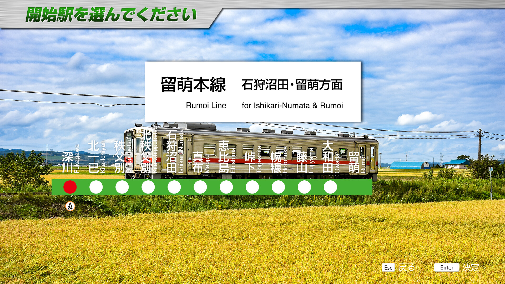
Introducing
The Rumoi Line is a 14.4 km long JR Hokkaido line connecting Fukagawa Station in Fukagawa City, Hokkaido to Ishikari-Numata Station in Numata Town, Uryu County, Hokkaido.
The line used to run 66.8 km to Mashike Station in Mashike-cho, Mashike-gun, Hokkaido, but the Rumoi - Mashike line was discontinued in December 2016, followed by the Ishikari-Numata - Rumoi line in April 2023, leaving only Fukagawa - Ishikari-Numata as the only remaining line.
In the past, the Rumoi Line was serviced by the express train "Mashike," which runs directly from Sapporo Station, the express train "Rumoi," which runs directly from Asahikawa Station, and the "SL Suzuran" steam locomotive, a C11 class steam locomotive. As of March 2024, only seven regular trains per day operate on the in-bound line and out-bound lines.
Departing from Fukagawa Station, the train heads north through the Ishikari Plain, crossing the Ebishima Pass with its series of large curves and gradients on its way to Rumoi Station. Along the way, you will be able to experience Hokkaido's unique character in many places, such as Kita-Chippubetsu Station with its wooden platform and Ebishima Station adjacent to the station building where the TV drama "Suzuran" was set.
This DLC includes the in-bound line and out-bound lines between Fukagawa and Rumoi, including the discontinued section. We have decided to create this DLC not only as a driving experience, but also to preserve the scenery and memories of the discontinued section in the form of a simulator. We hope you will enjoy driving a line that you will never ride again with this DLC.
Key data
- Line Length: 50.1 km
- Number of stations: 12
- Safety system: ATS-Dn / ATS-Sn
- Train model: KiHa 54 series (1 car)
- Max speed: 85 km/h
- Max speed after signals:
- Reduced speed (green/yellow): 65 km/h
- Caution (yellow): 45 km/h
- Speed restriction (yellow/yellow): 25 km/h
- Routes:
- Rumoi ~ Fukagawa (4920D) : "Local" type - 9 stations - 50.1 km
- Rumoi ~ Asahikawa (4922D) : "Local" type - 12 stations - 50.1 km (can't go above Fukagawa)
- Rumoi ~ Fukagawa (4924D) : "Local" type - 10 stations - 50.1 km
- Rumoi ~ Fukagawa (4926D) : "Local" type - 10 stations - 50.1 km
- Fukagawa ~ Rumoi (回5921D) : "Not in service" type - 2 stations - 50.1 km (direct train)
- Fukagawa ~ Rumoi (4921D) : "Local" type - 5 stations - 50.1 km
- Fukagawa ~ Rumoi (4923D) : "Local" type - 10 stations - 50.1 km
- Fukagawa ~ Rumoi (4925D) : "Local" type - 11 stations - 50.1 km
- Fukagawa ~ Rumoi (4929D) : "Local" type - 10 stations - 50.1 km
- Automatic announcements: Yes
- Conductor announcements: No
- Driver announcement (pointing-and-calling): Yes
Features
This line can be run in both directions. The timetable is displayed directly in the cab.
When heading towards Rumoi, about 1.8km before reaching Mappu station, you can see a fox crossing the track.
ATS-Dn is only used at the exit/entry to Fukagawa station, the rest is on ATS-Sn.
Stations list
| Station name |
Japanese name |
Distance (km) | JRETS connections |
|---|---|---|---|
| Fukagawa | 深川 | 0 | |
| Kita-Ichiyan | 北一已 | 3,8 | |
| Chippubetsu | 秩父別 | 8,8 | |
| Kita-Chippubetsu | 北秩父別 | 11,2 | |
| Ishikari-Numata | 石狩沼田 | 14,4 | |
| Mappu | 真布 | 17,8 | |
| Ebishima | 恵比島 | 20,7 | |
| Tōgeshita | 峠下 | 28,3 | |
| Horonuka | 幌糠 | 34,5 | |
| Fujiyama | 藤山 | 40,0 | |
| Ōwada | 大和田 | 44,2 | |
| Rumoi | 留萌 | 50,1 |
Movie
Useful links
Wikipedia: https://en.wikipedia.org/wiki/Rumoi_Main_Line
Driver's guide and timetables: https://docs.google.com/spreadsheets/d/1EAuUIUOkjAcV558y-fTwY7o84DDYdJfihv6WI9lswqU/edit#gid=965613808
Oga Line

Introducing
The Oga Line is a 26.4 km long line connecting Oiwake Station in Akita City, Akita Prefecture, to Oga Station in Oga City, Akita Prefecture. All trains operate directly to the Ou Line, and this DLC includes a 39.4 km long section, including a portion between Akita Station and Oiwake Station on the Ou Line.
The Oga Line began service in 1913 as the Funakawa Light Rail Line connecting Oiwake and Futada Stations, and later in 1916 the entire line was opened to Funakawa Station, which is now Oga Station. Currently, only regular trains operate on the line, but in the past, the night express train "Oga" departing from Ueno Station used to run to Oga Station as a temporary train.
The maximum speed changes depending on the section of track (Ou Line section: 95 km/h, Oga Line section: 85 km/h), and all trains are operated as one-man trains. (*In this DLC, implemented in two-man specification)
The EV-E801 series AC battery-powered trains began operating on the Oga Line in 2017, and now all trains on the line are operated by the EV-E801 series. The EV-E801 Series runs in two modes: between Akita Station and Oiwake Station, the electrified section, it runs on electricity from overhead wires, while between Oiwake Station and Oga Station, the non-electrified section, it runs on electricity stored in storage batteries with the pantographs down. The first track at Oga Station is equipped with recharging facilities so that passengers can recharge their batteries during the time the train stops before turning around.
On the way to Oiwake Station, the Ou Line section runs through a bedroom town of Akita City. After leaving Oiwake Station, the train enters the Oga Line section, where fields along the line become conspicuous, and from the Wakimoto Station area, the train winds through mountainous areas. Please enjoy driving the EV-E801 series AC battery-powered train with the sightseeing spot "Mt. Kanpuzan" in Oga City, Akita Prefecture in this DLC.
Key data
- Line Length: 39.4 km
- Number of stations: 13
- Safety system: ATS-Ps
- Train model: EV-E801 serie (2 cars)
- Max speed:
- Akita ~ Oiwake: 95 km/h
- Oiwake ~ Oga : 85 km/h
- Max speed after signals:
- Reduced speed (green/yellow): 65 km/h (75km/h for Akita ~ Oiwake)
- Caution (yellow): 45 km/h (55km/h for Akita ~ Oiwake)
- Speed restriction (yellow/yellow): 25 km/h
- Routes:
- Akita ~ Oga (1127M) : "Local" type - 12 stations - 39.4 km
- Akita ~ Oga (1131M) : "Local" type - 12 stations - 39.4 km
- Akita ~ Oga (1133M) : "Local" type - 12 stations - 39.4 km
- Akita ~ Oga (1135M) : "Local" type - 12 stations - 39.4 km
- Automatic announcements: No
- Conductor announcements: Yes
- Driver announcement (pointing-and-calling): Yes
Features
As timetables are not available on the screen, we recommend using the timetables or displaying the STA indicator.
On arrival at Oiwake station, you can listen to the procedure for switching from the electrified network to the batteries.
Stations list
| Station name |
Japanese name |
Distance from Oiwake (km) | JRETS connections |
|---|---|---|---|
| Akita | 秋田 | 13 | |
| Tsuchizaki | 土崎 | 5,9 | |
| Kami-Iijima | 上飯島 | 3,4 |
|
| Oiwake | 追分 | 0 | |
| Detohama | 出戸浜 | 5,1 | |
| Kamifutada | 上二田 | 8,3 | |
| Futada | 二田 | 10,4 | |
| Tennō | 天王 | 13,2 | |
| Funakoshi | 船越 | 14,9 | |
| Wakimoto | 脇本 | 18,9 | |
| Hadachi | 羽立 | 23,7 | |
| Oga | 男鹿 | 26,6 |
Movie
Useful links
Wikipedia: https://en.wikipedia.org/wiki/Oga_Line
Driver's guide and timetables: https://docs.google.com/spreadsheets/d/1veRrSGC2B-1JWe4Hb5_0KAKxrMIHsqz_-CmTq8uOJLw/edit#gid=1213761562
Narita Line
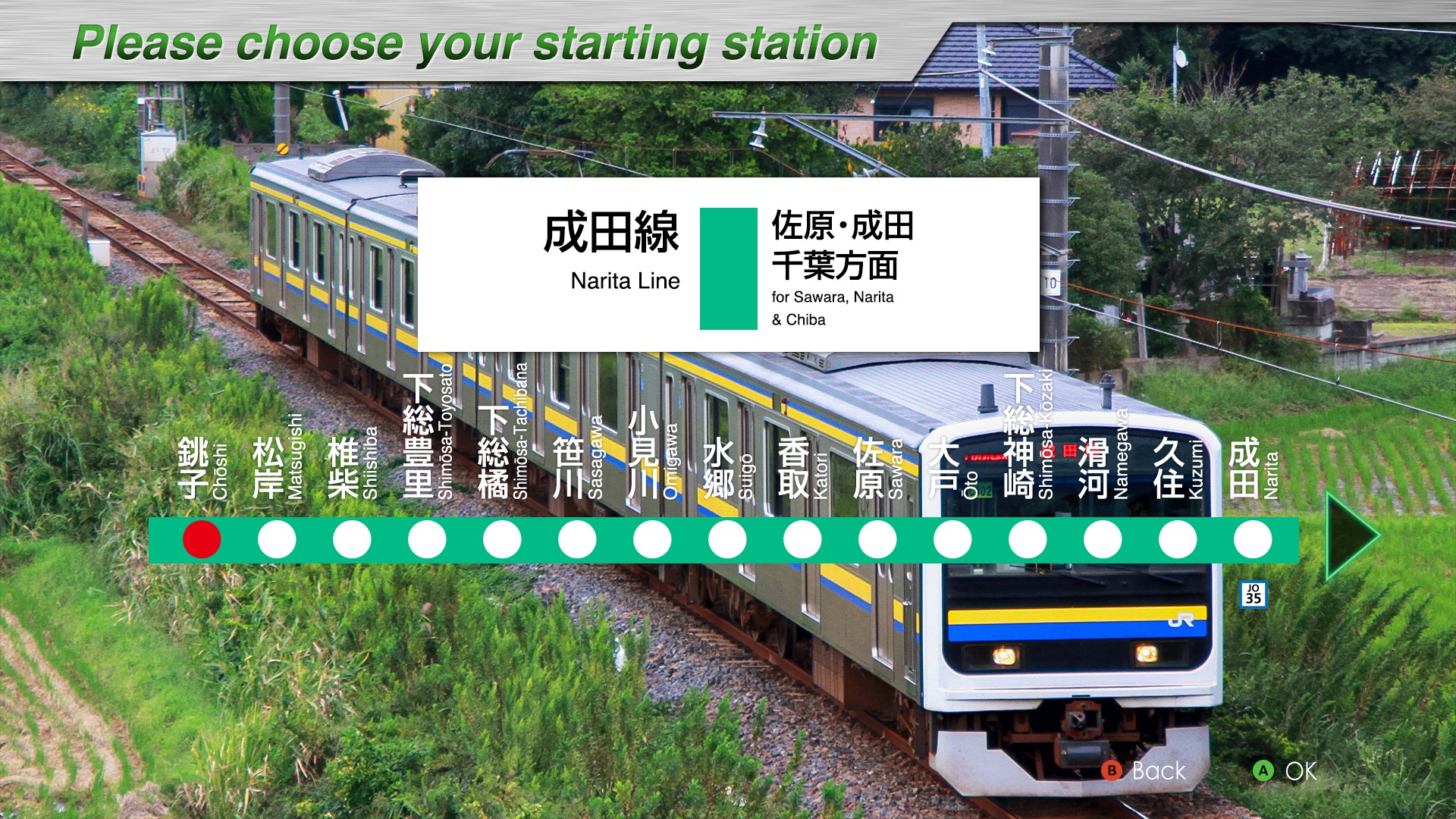
Introducing
The Narita Line is a 75.4 km long line connecting Matsugishi Station in Chōshi City, Chiba Prefecture, to Sakura Station in Sakura City, Chiba Prefecture.This DLC includes a 94.7 km long section, including a portion between Chōshi and Matsugishi Stations and between Sakura and Chiba Stations on the Sōbu Main Line.The Narita Line, which opened between Narita and Sakura stations in 1897, has a history of more than 120 years.In the past, the “Suigo” express train operated between Tokyo Station and Chōshi Station via the Narita Line.Currently, only regular trains run from Chōshi Station to Sakura Station.
The Narita Line runs along the Tone River after leaving Matsugishi Station.The line heads for Narita Station via Katori Station, the gateway to Katori Jingu Shrine, one of the three shrines in the eastern part of Japan; Sawara Station, where you can enjoy the atmosphere of a Koedo town; and Shimōsa-Kōzaki Station, the nearest station to the historic sake brewery town.The long, quiet stretch of fields stretches all the way to Narita Station.From Narita Station to Sakura Station, the “Narita Express” express train runs between central Tokyo and Narita Airport, making this a busy section with many trains.
Key data
- Line Length: 94.7 km
- Number of stations: 22
- Safety system: ATS-P
- Train model: 209-2100 serie (4 cars)
- Max speed:
- Choshi - Matsugishi: 95 km/h
- Matsugishi - Narita: 85 km/h
- Narita - Chiba: 110 km/h
- Max speed after signals:
- Reduced speed (green/yellow): 65 km/h → Narita → 75 km/h
- Caution (yellow): 45 km/h → Narita → 55 km/h
- Speed restriction (yellow/yellow): 25 km/h
- Reduced speed (green/yellow): 65 km/h → Narita → 75 km/h
- Routes:
- Chōshi ~ Chiba (436M) : Local train - 22 stations - 94.7 km
- Chōshi ~ Chiba (450M) : Local train - 22 stations - 94.7 km
- Chōshi ~ Narita (2446M) : Local train - 15 stations - 65.5 km
- Chōshi ~ Narita (2462M) : Local train - 15 stations - 65.5 km
- Automatic announcements: No
- Conductor announcements: Yes
- Driver announcement (pointing-and-calling): Yes
Stations list
| Station name |
Japanese name |
Distance from Sakura (km) | JRETS connections |
|---|---|---|---|
| Chōshi | 銚子 | 78,6 | |
| Matsugishi | 松岸 | 75,4 | |
| Shiishiba | 椎柴 | 71,0 | |
| Shimōsa-Toyosato | 下総豊里 | 66,2 | |
| Shimōsa-Tachibana | 下総橘 | 62,9 | |
| Sasagawa | 笹川 | 57,7 | |
| Omigawa | 小見川 | 52,7 | |
| Suigo | 水郷 | 47,5 | |
| Katori | 香取 | 43,6 | Kashima |
| Sawara | 佐原 | 40,0 | Kashima (last stop) |
| Ōto | 大戸 | 36,1 | |
| Shimōsa-Kōzaki | 下総神崎 | 31,6 | |
| Namegawa | 滑河 | 25,5 | |
| Kuzumi | 久住 | 20,0 | |
| Narita | 成田 | 13,1 | Sōbu (Rapid) - Narita |
| Shisui | 酒々井 | 6,4 | Sōbu (Rapid) - Narita |
| Sakura | 佐倉 | 0 | Sōbu (Rapid) - Narita |
| Monoi | 物井 | 4,2 | Sōbu (Rapid) - Narita |
| Yotsukaidō | 四街道 | 8,4 | Sōbu (Rapid) - Narita |
| Tsuga | 都賀 | 11,9 | Sōbu (Rapid) - Narita |
| Higashi-Chiba | 東千葉 | 15,2 | Sōbu (Rapid) - Narita |
| Chiba | 千葉 | 16,1 | Sōbu (Rapid) - Narita |
Movie
Useful links
Wikipedia: https://en.wikipedia.org/wiki/Narita_Line
Driver's guide and timetables: https://docs.google.com/spreadsheets/d/1aTQpAJafecr-3dkvLx5jmTgmRQObA0G_UOP97VRIgZ4/edit?gid=1348098309#gid=1348098309
Kashima Line
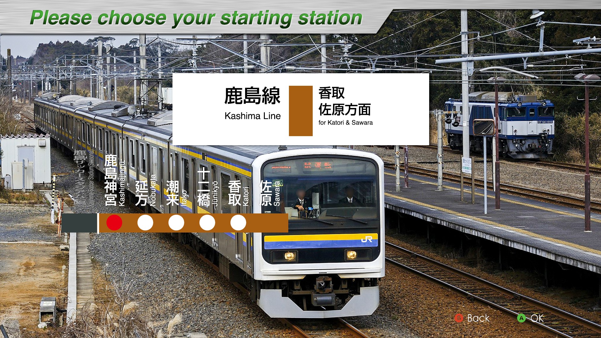
Introducing
The Kashima Line is a 17.4 km long line connecting Kashima-Soccer Stadium Station in Kashima City, Ibaraki Prefecture, to Katori Station in Katori City, Chiba Prefecture.This DLC includes a 21.0 km long section, including a portion between Katori and Sawara Stations on the Narita Line.It has a relatively short history in the JR-EAST service area, having opened in 1970.Although the Kashima Line begins at Katori Station, the first station for operational purposes is Sawara Station (some trains depart from Narita Station), so trains run on the Narita Line tracks between Katori Station and Sawara Station.In the past, the “Ayame” express train operated up to five round trips per day.As of 2024, there is one round-trip rapid train per day that runs directly from the Tokyo area.In addition, since Kashima-Soccer Stadium Station is a temporary station, trains operate between Kashima Jingū Station and Sawara Station except when events are held at Kashima Soccer Stadium.Most sections of the line run on elevated tracks, allowing passengers to enjoy scenic views of Kitaura, Hitachi-Tone River, and Tone River, which are typical of the Suigou area.
Enjoy the DLC of the Kashima Line while enjoying the rural scenery of the Hokuso Plateau spreading out from the elevated line.
Key data
- Line Length: 21 km
- Number of stations: 7
- Safety system: ATS-P
- Train model: 209-2100 serie (4 cars)
- Max speed: 85 km/h
- Max speed after signals:
- Reduced speed (green/yellow): 65 km/h
- Caution (yellow): 45 km/h
- Speed restriction (yellow/yellow): 25 km/h
- Routes:
- Kashima-Soccer Stadium ~ Kashimajingū (回522M): Train local - 2 stations - 3.2 km
- Kashimajingū ~ Sawara (522M): Train local - 6 stations - 17.8 km
- Kashimajingū ~ Sawara (524M): Train local - 6 stations - 17.8 km
- Kashimajingū ~ Sawara (536M): Train local - 6 stations - 17.8 km
- Kashimajingū ~ Sawara (540M): Train local - 6 stations - 17.8 km
- Automatic announcements: No
- Conductor announcements: Yes
- Driver announcement (pointing-and-calling): Yes
Stations list
| Station name |
Japanese name |
Distance from Katori (km) | JRETS connections |
|---|---|---|---|
| Kashima Soccer Stadium | 鹿島サッカースタジアム | 17,4 | |
| Kashima-Jingū | 鹿島神宮 | 14,2 | |
| Nobukata | 延方 | 10,4 | |
| Itako | 潮来 | 5,2 | |
| Jūnikyō | 十二橋 | 3,0 | |
| Katori | 香取 | 0 | Narita |
| Sawara | 佐原 | 3,6 | Narita |
Movie
Useful links
Wikipedia: https://en.wikipedia.org/wiki/Kashima_Line
Driver's guide and timetables: https://docs.google.com/spreadsheets/d/1XBnmAE2hFmaYfNpQamEQ5viHpAa3rmcb_CKXpFe5pzg/edit?gid=2142090860#gid=2142090860
Utsunomiya Line

Introducing
Utsunomiya Line is the nickname for trains operating on the 163.3 km long section of the Tōhoku Main Line (between Tōkyō Station and Morioka Station) between Tōkyō and Kuroiso Station.The Utsunomiya Line nickname has been in use since March 10, 1990, at the suggestion of the municipalities along the railway line. In the past, many limited express and sleeper trains to Tōhoku and Hokkaidō used to run, but now Local and rapid trains dominate the timetable.
The current operation system is separated at Utsunomiya Station. South of Utsunomiya, the Ueno Tōkyō Line and Shōnan Shinjuku Line provide commuter and school transportation in the Tōkyō metropolitan area. On the section north of Utsunomiya (some early mornings are between Oyama/Koganei and Utsunomiya), one-man operation is used to provide interregional transportation within Tochigi Prefecture.
After leaving Kuroiso Station, the train heads to Ueno Station, the northern gateway to Tōkyō, and Tōkyō Station, the center of Tōkyō, via Nasu-Shiobara Station, the gateway to Nasu, Utsunomiya Station, known as the city of dumplings, and Omiya Station, the largest terminal in Saitama Prefecture.
We hope you will enjoy the Utsunomiya Line DLC as you travel through the Kantō Plain, experiencing the changing landscape from Tochigi Prefecture to Tōkyō, including sprawling rural landscapes, suburban residential areas, and buildings in the city center.
Key data
- Total length : 163.3 km
- Number of stations : 34
- Safety system : ATP-P
- Train model : E233-3000 series (10/15 cars)
- Max speed:
- Kuroiso ~ Utsunomiya : 100 km/h
- Utsunomiya ~ Tōkyō: 110 km/h
- Max speed after signals :
- Reduced speed (green/yellow): 65 km/h → Utsunomiya → 75 km/h
- Caution (yellow): 45 km/h → Utsunomiya → 55 km/h
- Speed restriction (yellow/yellow): 25 km/h
- Routes:
- Koganei ~ Tōkyō (1539E) : Local train - 15 cars - 20 stations - 88.3 km
- Utsunomiya ~ Tōkyō (1567E) : Local train - 15 cars - 24 stations - 109.5 km
- Koganei ~ Tōkyō (1591E) : Local train - 15 cars - 20 stations - 88.3 km
- Kuroiso ~ Ueno (3520M) : Rapid "Rabbit" train - 10 cars - 24 stations - 159.7 km
- Automatic announcements: No
- Conductor announcements: Yes
- Driver announcement (pointing-and-calling): Yes
Features
Train no. 1567E also operates on the Tokaido line, making it possible to link Utsunomiya ~ Tōkyō ~ Hiratsuka, a journey of over 170km.
Stations list
| Station name |
Japanese name |
Services | JRETS connections |
|
|---|---|---|---|---|
| Local |
Rapide Rabbit | |||
| Kuroiso | 黒磯 | ● | ● |
|
| Nasushiobara | 那須塩原 | ● | ● |
|
| Nishi-Nasuno | 西那須野 | ● | ● |
|
| Nozaki | 野崎 | ● | ● |
|
| Yaita | 矢板 | ● | ● |
|
| Kataoka | 片岡 | ● | ● |
|
| Kamasusaka | 蒲須坂 | ● | ● |
|
| Ujiie | 氏家 | ● | ● |
|
| Hōshakuji | 宝積寺 | ● | ● |
|
| Okamoto | 岡本 | ● | ● |
|
| Utsunomiya | 宇都宮 | ● | ● |
|
| Suzumenomiya | 雀宮 | ● | ● |
|
| Ishibashi | 石橋 | ● | ● |
|
| Jichi Medical University | 自治医大 | ● | ● |
|
| Koganei | 小金井 | ● | ● |
|
| Oyama | 小山 | ● | ● |
|
| Mamada | 間々田 | ● | | |
|
| Nogi | 野木 | ● | | |
|
| Koga* | 古河 | ● | ● |
|
| Kurihashi | 栗橋 | ● | | |
|
| Higashi-Washinomiya | 東鷲宮 | ● | | |
|
| Kuki | 久喜 | ● | ● |
|
| Shin-Shiraoka | 新白岡 | ● | | |
|
| Shiraoka | 白岡 | ● | | | |
| Hasuda | 蓮田 | ● | ● |
|
| Higashi-Ōmiya | 東大宮 | ● | | |
|
| Toro | 土呂 | ● | | |
|
| Ōmiya | 大宮 | ● | ● |
JU Takasaki |
| Saitama-Shintoshin | さいたま新都心 | ● | | |
JU Takasaki |
| Urawa | 浦和 | ● | ● |
JU Takasaki |
| Akabane | 赤羽 | ● | ● |
JU Takasaki |
| Oku | 尾久 | ● | | |
JU Takasaki |
| Ueno | 上野 | ● | ● |
JJ Jōban JU Takasaki JY Yamanote |
| Tokyo |
東京 | ● |
JT Tōkaidō JY Yamanote JO Sōbu (Rapid) JE Keiyō (last stop) JJ Jōban |
|
Movie
Useful links
Wikipedia : https://en.wikipedia.org/wiki/Utsunomiya_Line
Driver's guide and timetables: https://docs.google.com/spreadsheets/u/0/d/1kbnimHrP3imiH2sykZER_3eT8ikuv-SbDszYWIuVu9w/edit
Yokosuka line
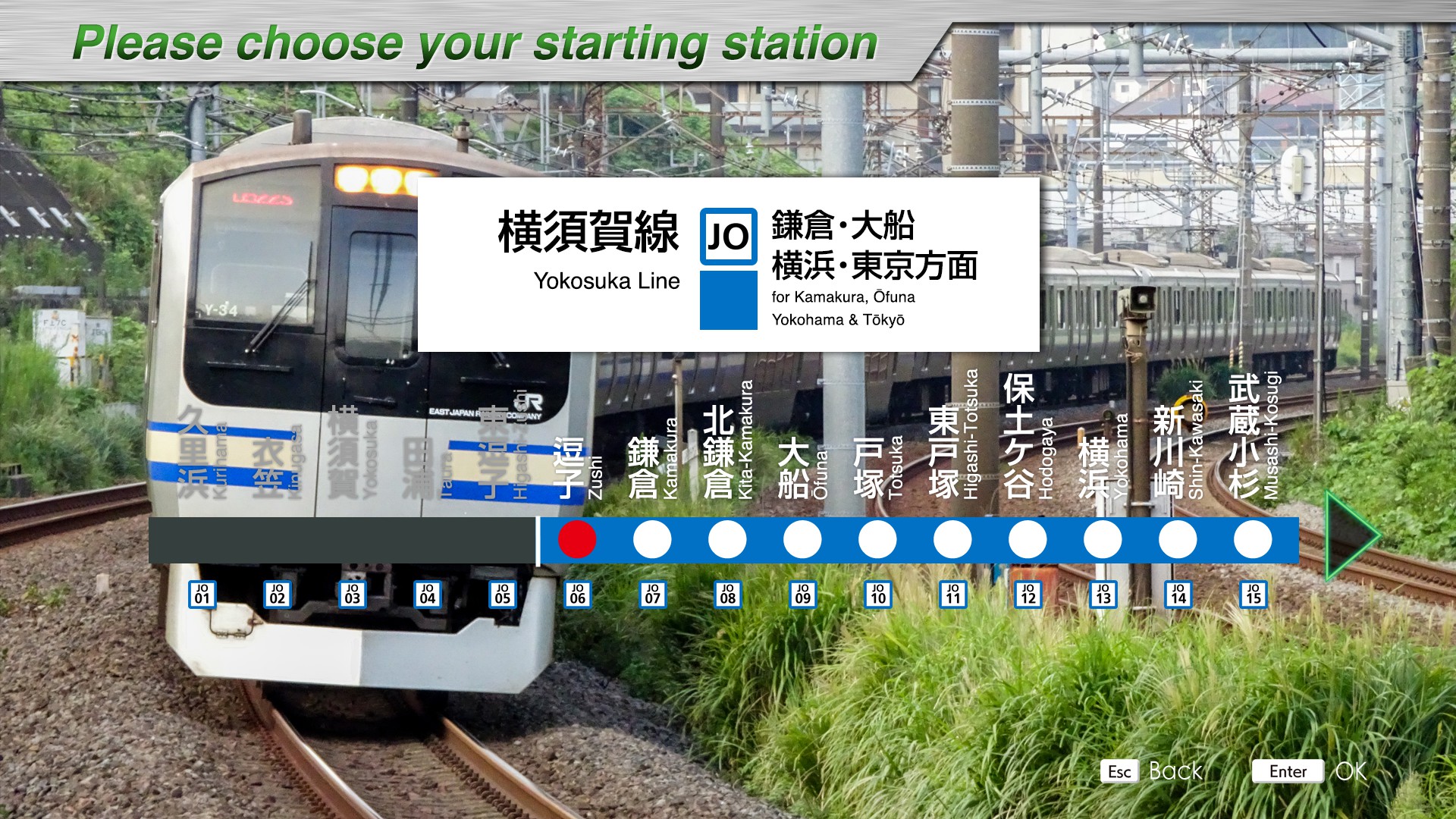
Introducing
The Yokosuka Line is a 23.9 km long line connecting Kurihama Station in Yokosuka City, Kanagawa Prefecture and Ōfuna Station in Kamakura City, Kanagawa Prefecture. Although the official name of Ōfuna Station to Tōkyō Station is Tōkaido main line, trains run directly from Kurihama Station to Tōkyō Station, so the line between Kurihama and Tōkyō Stations is known as the Yokosuka Line.
In 1980, the Sobu Rapid Line started direct service from Tōkyō Station to Chiba, and it can go to Chiba and Narita Airport and other areas in Chiba Prefecture. The Narita Express, a limited express train bound for Narita Airport, and other trains with various destinations can be seen.
In 2001, the Shōnan Shinjuku Line began direct service from Zushi Station to Utsunomiya Station, providing convenient access to Shinjuku Station and other Tōkyō subcenters and to the Utsunomiya Line.
The train leaves Kurihama Station for Yokohama Station via Yokosuka Station, a military port town; Kamakura Station, famous for the Daibutsu statue and Tsurugaoka Hachiman Shrine; and Ōfuna Station, where the train joins the Tōkaidō Main Line.
After Yokohama Station, the line separates from the Tōkaidō Main Line near Tsurumi Station and heads for Shinagawa via Shin-Kawasaki Station and Musashi-Kosugi Station, where the Shin-Tsurumi Engine Works is spead, while running alongside the Tōkaidō Shinkansen.
After Shinagawa Station, the line goes underground to Tōkyō Station, its final destination.
We hope you enjoy the various landscapes from the suburbs to the city and the many parallel trains.
Key data
- Total length: 73.3 km
- Number of stations: 19
- Safety system: ATS-P
- Train model : E217 series (4/11/15 cars)
- Max speed:
- Kurihama - Yokosuka: 65km/h
- Yokosuka - Ofuna: 95km/h
- Ofuna - Shinagawa: 120km/h
- Shinagawa - Tokyo: 100km/h
- Max speed after signals:
- Reduced speed (green/yellow) : 65 km/h → Ofuna → 75 km/h
- Caution (yellow) : 45 km/h → Ofuna → 55 km/h
- Speed restriction (yellow/yellow): 25 km/h
- Routes:
- Zushi ~ Kimitsu (stop at Tokyo) (730S) : Local train - 14 stations - 57.8 km
- Kurihama ~ Zushi (834H) : Local train - 6 stations - 15.5 km
- Zushi ~ Kimitsu (stop at Tokyo) (1204S) : Local train - 14 stations - 57.8 km
- Zushi ~ Kazusa-Ichinomiya (stop at Tokyo) (1330S) : Local train - 14 stations - 57.8 km
- Kurihma ~ Zushi (1704H) : Local train - 6 stations - 15.5 km
- Automatic announcements: Yes
- Conductor announcements: Yes
- Driver announcement (pointing-and-calling): Yes
Stations list
| Station name |
Japanese name |
Distance from Tokyo (km) | JRETS connections |
|---|---|---|---|
| Kurihama | 久里浜 | 73,3 | |
| Kinugasa | 衣笠 | 68,7 | |
| Yokosuka | 横須賀 | 65,3 | |
| Taura | 田浦 | 63,2 | |
| Higashi-Zushi | 東逗子 | 59,8 | |
| Zushi | 逗子 | 57,8 | |
| Kamakura | 鎌倉 | 53,9 | |
| Kita-Kamakura | 北鎌倉 | 51,7 | |
| Ōfuna | 大船 | 49,4 |
JK Negishi (last stop) JT Tōkaidō |
| Totsuka | 戸塚 | 43,8 | JT Tōkaidō |
| Higashi-Totsuka | 東戸塚 | 39,6 | |
| Hodogaya | 保土ヶ谷 | 34,7 | |
| Yokohama | 横浜 | 31,7 |
JK Negishi JT Tōkaidō |
| Shin-Kawasaki | 新川崎 | 19,5 | |
| Musashi-Kosugi | 武蔵小杉 | 16,8 | JN Nambu |
| Nishi-Ōi | 西大井 | 10,4 | |
| Shinagawa | 品川 | 6,8 |
JT Tōkaidō JY Yamanote JJ Jōban |
| Shimbashi | 新橋 | 1,9 |
JT Tōkaidō JY Yamanote JJ Jōban |
| Tokyo | 東京 | 0 |
JT Tōkaidō JY Yamanote JO Sōbu (Rapid) JE Keiyō (last stop) JJ Jōban JC Chūō (last stop) JU Utsunomiya (last stop) |
Movie
Useful links
Wikipédia : https://en.wikipedia.org/wiki/Yokosuka_Line
Driver's guide and timetables: https://docs.google.com/spreadsheets/d/1Yne-2OjeW4naU7rVJMuMl6rdcV9ZVUuq2nKCRCRanM4/edit?gid=604315636#gid=604315636
Ōme Line
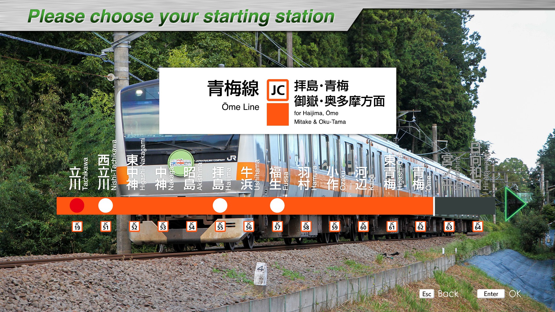
Introducing
The Ōme Line is a 37.2 km long line connecting Tachikawa Station in Tachikawa City, Tōkyō, and Okutama Station in Okutama-town, Nishitama-county, Tōkyō. The line runs through residential areas from Tachikawa Station to Ōme Station, but from Ōme Station onward it runs along the Tama River through the mountains. The area between Ōme Station and Okutama Station is known as the Adventure Line, and although it is in Tōkyō, it is an area where visitors can enjoy abundant nature and activities right after getting off the station.
The “Holiday Rapid Okutama” train used to run directly from Shinjuku Station to Okutama Station on holidays, but the train line is now separated at Ōme Station, and the “Holiday Rapid Okutama” between Ōme and Okutama Stations is operated as a temporary train.
After leaving Tachikawa Station, the train runs through a residential area until it reaches Ōme Station. On the way, the train passes through Nishi-Tachikawa Station, the nearest station to the Shōwa Kinen Park and Haijima Station, a major transportation hub. There are many trains to Ōme Station, and the line is double-tracked up to the Higashi- Ōme Station area.
After leaving Ōme Station, trains travel along the valley along the Tama River to Okutama Station. The scenery is very different from the scenery up to Ōme Station, with a single-track line and lush greenery of trees and mountains.
The Okutama area is also home to a number of tourist attractions such as canoeing and ranching, and the entire Okutama line has been converted into a hotel, called the “Along railway line marugoto Hotel” .
We hope you will enjoy the Ōme Line, which has two distinctive features a double track running through a residential area and a single track running through the mountains.
Key data
- Total length: 37.2 km
- Number of stations: 25
- Safety system: ATS-P
- Train model : E233-0 series (4/6/10 cars)
- Max speed: 85km/h
- Max speed after signals:
- Reduced speed (green/yellow): 65 km/h → Ōme → 75 km/h
- Caution (yellow) : 45 km/h → Ōme → 55 km/h
- Speed restriction (yellow/yellow): 25 km/h
- Routes :
- Tachikawa ~ Kabe (715) : Local train - 11 stations - 15.9 km
- Tachikawa ~ Ōme (843) : Local train - 13 stations - 18.5 km
- Tachikawa ~ Ōme (1379T) : Local train - 13 stations - 18.5 km
- Tachikawa ~ Ōme (721T) : "Holiday Rapid Okutama" train - 5 stations - 18.5 km
- Ōme ~ Okutama (7847) : "Holiday Rapid Okutama" train - 3 stations - 18.7 km
- Ōme ~ Okutama (1103) : Local train - 13 stations - 18.7 km
- Ōme ~ Okutama (1407) : Local train - 13 stations - 18.7 km
- Automatic announcements: Yes
- Conductor announcements: Yes
- Driver announcement (pointing-and-calling): Yes
Stations list
| Station name |
Japanese name |
Distance from Tachikawa (km) | Local |
Holiday Rapid Okutama | JRETS connections |
|---|---|---|---|---|---|
| Tachikawa | 立川 | 0 | ● | ● |
JN Nambu (last stop) |
| Nishi-Tachikawa | 西立川 | 1,9 | ● | ● | |
| Higashi-Nakagami | 東中神 | 2,7 | ● | | | |
| Nakagami | 中神 | 3,6 | ● | | | |
| Akishima | 昭島 | 5,0 | ● | | | |
| Haijima | 拝島 | 6,9 | ● | ● | |
| Ushihama | 牛浜 | 8,6 | ● | | | |
| Fussa | 福生 | 9,6 | ● | ● | |
| Hamura | 羽村 | 11,7 | ● | | | |
| Ozaku | 小作 | 14,1 | ● | | | |
| Kabe | 河辺 | 15,9 | ● | | | |
| Higashi-Ōme | 東青梅 | 17,2 | ● | | | |
| Ōme | 青梅 | 18,5 | ● | ● | |
| Miyanohira | 宮ノ平 | 20,6 | ● | | | |
| Hinatawada | 日向和田 | 21,4 | ● | | | |
| Ishigamimae | 石神前 | 22,4 | ● | | | |
| Futamatao | 二俣尾 | 23,6 | ● | | | |
| Ikusabata | 軍畑 | 24,5 | ● | | | |
| Sawai | 沢井 | 25,9 | ● | | | |
| Mitake | 御嶽 | 27,2 | ● | ● | |
| Kawai | 川井 | 30,0 | ● | | | |
| Kori | 古里 | 31,6 | ● | | | |
| Hatonosu | 鳩ノ巣 | 33,8 | ● | | | |
| Shiromaru | 白丸 | 35,2 | ● | | | |
| Okutama | 奥多摩 | 37,2 | ● | ● |
Movie
Useful links
Wikipédia : https://fr.wikipedia.org/wiki/Ligne_%C5%8Cme
Guide de conduite et tables horaire : https://docs.google.com/spreadsheets/d/1VvV9iCUSbZr_p1yQBoHiQscnLeLRseGG79Awg2kNqkY/edit?gid=967713949#gid=967713949
Tōkaidō Freight Line
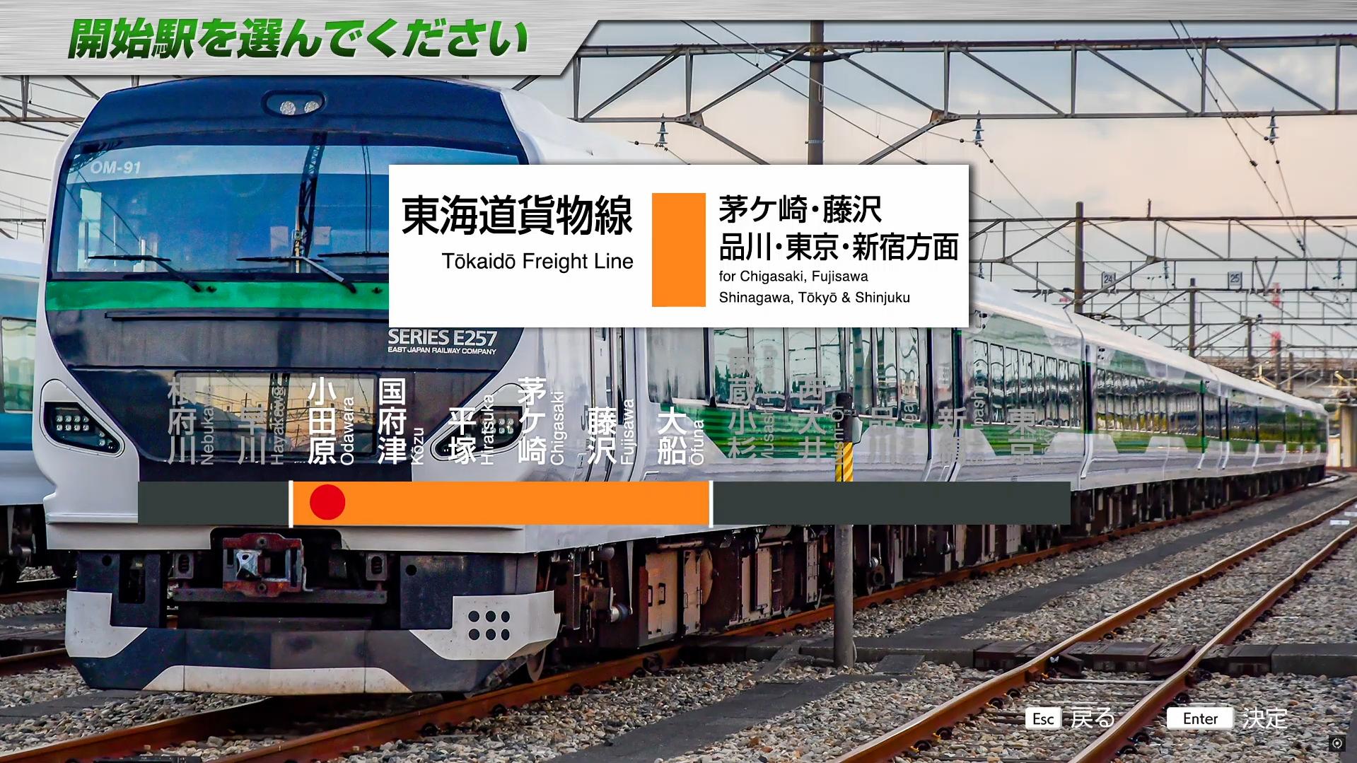
Introducing
Tōkaidō Freight Line is the common name for tracks on the Tōkaidō Main Line dedicated to freight trains that are separated from passenger trains (freight lines) and branch lines attached to the main line that are mainly used by freight trains (freight branch lines).
Generally, it refers to a series of freight lines and freight branch lines from Hamamatsuchō Station to Odawara Station.
The Tōkaidō Freight Line runs a variety of freight trains to and from the Kansai, Kyūshū regions, some limited express “Shōnan” trains during morning and evening hours, and test runs of new trains and crew training during daytime hours. The trains run alongside passenger lines, pass through long tunnels and elevated shelters through residential areas, and pass through a number of freight stations, allowing to enjoy the unique view of the freight line.
In this DLC, you can drive from Odawara Station to Tōkyō Station via the Tōkaidō Freight Line and Hinkaku Line (Yokosuka Line), which are separate routes from passenger lines, and to Shinjyuku Station via the Yamanote Freight Line.
We hope you will enjoy the different scenery from the passenger line.
Key data
- Total length: 107.8 km
- Number of stations: 11
- Safety system: ATS-P
- Train model: E257-2000 and E257-5500 series (5/9 cars)
- Max speed:
- Nebukawa ~ Odawara: 110km/h
- Odawara ~ Ofuna: 120km/h
- Ofuna ~ Musashi-Kosugi: 95km/h
- Musashi-Kosugi ~ Osaki / Shinagawa: 120km/h
- Osaki ~ Shinjuku: 95km/h
- Shinagawa ~ Tokyo: 100km/h
- Max speed after signals:
- Reduced speed (green/yellow): 75 km/h
- Caution (yellow): 55 km/h
- Speed restriction (yellow/yellow): 25 km/h
- Routes:
- Nebukawa ~ Odawara (回3092M): "Out of service" train - 2 stations - 6.5 km
- Odawara ~ Tōkyō (3078M): Limited Express "Shōnan" 8 - 6 stations - 94.1 km
- Odawara ~ Shinjuku (3092M): Limited Express"Shōnan" 22 - 6 stations - 94.7 km
- Odawara ~ Shinjuku (3096M): Limited Express "Shōnan" 26 - 6 stations - 94.7 km
- Odawara ~ Tsurumi (9078M): Extra train "Atami" to Takao - 2 stations - 63 km
- Automatic announcements: Yes
- Conductor announcements: Yes
- Driver announcement (pointing-and-calling): Yes
Stations list
| Station | Japanese name |
Distance (km) | Out of service |
Shōnan 8 |
Shōnan 22/26 | Extra Atami |
JRETS Connections |
|---|---|---|---|---|---|---|---|
| Nebukawa | 根府川 | 0 |
● | JT Tōkaidō | |||
| Odawara | 小田原 | 6.5 |
● | ● | ● | ● | JT Tōkaidō |
| Chigasaki | 茅ヶ崎 | 31.8 |
● | ● | | | JT Tōkaidō | |
| Fujisawa |
藤沢 | 39.3 |
● | ● | | | JT Tōkaidō | |
| Tsurumi |
鶴見 | 69.5 |
| | | | ● | JI Tsurumi JK Keihin–Tōhoku |
|
| To Tokyo |
|||||||
| Shinagawa |
品川 | 87.3 |
● | JT Tōkaidō JY Yamanote JK Keihin–Tōhoku JO Yokosuka JJ Jōban |
|||
| Shimbashi |
新橋 | 92.2 |
● | JT Tōkaidō JY Yamanote JK Keihin–Tōhoku JO Yokosuka JJ Jōban |
|||
| Tokyo |
東京 | 94.1 |
● |
JC Chūō (Rapid) (last stop) JU Utsunomiya (last stop) JO Sōbu (Rapid) JJ Jōban JY YamanoteJE Keiyō (last stop) JT Tōkaidō |
|||
| To Shinjuku | |||||||
| Osaki |
大崎 | 86.1 |
● |
JY Yamanote JA Saikyō |
|||
| Shibuya |
渋谷 | 91.3 |
● |
JY Yamanote JA Saikyō |
|||
| Shinjuku |
新宿 |
94.7 |
● |
JC Chūō (rapid) JY Yamanote JA Saikyō |
|||
Movie
Useful links
Wikipedia : https://en.wikipedia.org/wiki/Sh%C5%8Dnan_(train) - https://en.wikipedia.org/wiki/T%C5%8Dkaid%C5%8D_Freight_Line
Driver's guide and timetables : https://docs.google.com/spreadsheets/d/10Ax3vVv8FdYnr0aGVsV8CaO1bGowSGBuy4IOYuW4KFk/edit